Trail running Horberg Trail – Schwendau

Schwendau, Zillertal / Tux Alps
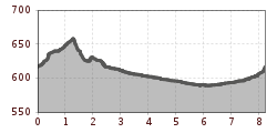
Route length: 8.1 km
Duration: 1:00 h

Tour information

  • Length: 8.1 km
  • Duration: 1:00 h
  • Elevation uphill:95 hm
  • Elevation downhill:95 hm
Highest point665 m

Starting point

car park Auenland Sidan, Kohlstatt 260a, 6283 Schwendau

Finishing point

car park Auenland Sidan, Kohlstatt 260a, 6283 Schwendau

Best time of year

  • January
  • February
  • March
  • April
  • May
  • June
  • July
  • August
  • September
  • October
  • November
  • December
Source: Zillertal Tourismus GmbH

Description

The starting point is the Horberg car park, where the route runs slightly uphill past the Horberg cable car valley station towards Kleinschwendberg. The route then heads down the valley via Burgstall to the Zimmereben. From there the route first leads west of the Ziller, then east of the river back to Schwendau.

Weather

Today

partly Cloudy
9°C/0°C
15%0l5 km/h

Fri

cloudy
11°C/-1°C
70%9l5 km/h

Sat

snow showers
5°C/-1°C
55%3.8l0 km/h
Newsletter

The mountain is calling? So does our newsletter!

In our monthly newsletter we reveal the best holiday tips for Tyrol.
