
The name of the starting point - "Schöne Aussicht" – more than lives up to its name.
Basic equipmentformountainhikingincludessturdy hiking bootswith a goodtread, a 30-35 literbackpack, and functionalclothingbased on thelayeringprinciple, includingsufficient spare clothes. Essential itemsare rain, cold, and sunprotection, adequatefluids and food, aswellas a first-aid kit and a charged mobile phone. A mapor a GPS devicesupportsorientation.
The informationservesas a guideline and does not claimtobe exhaustive. Equipment mustalwaysbeadaptedtothe planned route, weatherconditions, season, naturalhazards, environmental influences, and personal needs.
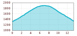
The popular hiking route starts at the car park right next to the "Schöne Aussicht" inn. With a pleasant ascent, the route first proceeds on a slight bend along the south-east slope to Carinthia. After a distinctive horse-shoe bend you then hike back "out of the valley" again, until you get to the forested ridge of the Strasskopf and the Lugger Alm (1630 m) which is not open for business. The route proceeds with not much incline to Roaner Alm.
