Winter hike Genuss am Mühlberg

Kössen / Chiemgau Alps
Difficulty ratings: medium
Route length: 8.7 km
Duration: 2:30 h

Nr. 21

Tour information

  • Requirement: medium
  • Length: 8.7 km
  • Duration: 2:30 h
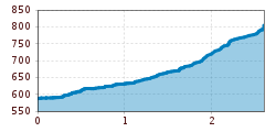
  • Elevation uphill:237 hm
  • Elevation downhill:236 hm
Highest point824 m

Starting point

Tourist Office Kössen

Finishing point

Tourist Office Kössen
  • Fitness level 2 / 6
  • Technique 2 / 6

Features

  • Suitable for families
  • suitable for pushchairs

Best time of year

  • January
  • February
  • March
  • April
  • May
  • June
  • July
  • August
  • September
  • October
  • November
  • December

Trail condition

Asphalt, hiking trail, forest road

Equipment

Breathable outdoor clothing, sturdy shoes, snacks and drinks, sun protection (sunglasses, sunscreen, and a hat), rain gear, cash; guest card if using the bus.
Source: TVB Kaiserwinkl

Description

Start at the information office in Kössen.
From there, walk through the town center and then turn left onto Mühlbergweg.
Follow this quiet road and watch for signs pointing toward Mühlberg. Then, at the Hohe Brücke parking lot, turn onto the hiking trail and follow it to the inn. Descend back along the municipal road to the Ruppen and Frohwies farms. Here, turn left onto the winter hiking trail to the Embach farm; from there, turn right onto the road leading into the Mosertal valley and, from the Hohe Brücke, follow the same trail back to the starting point.

Getting here

  • Parking

    In front of the Tourist Office in Kössen

Weather

Today

clear sky
31°C/11°C
5 km/h
Snow depth
Now: 0 cm,
Next snowfall: No data available
Go to weather forecast
Newsletter

The mountain is calling? So does our newsletter!

In our monthly newsletter we reveal the best holiday tips for Tyrol.