
Winter hike Rund um den Miesberg

Walchsee / Chiemgau Alps
Difficulty ratings: easy
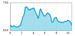
Route length: 10.7 km
Duration: 2:45 h

Nr.: 35

Tour information

  • Requirement: easy
  • Length: 10.7 km
  • Duration: 2:45 h
  • Elevation uphill:61 hm
  • Elevation downhill:56 hm
Highest point695 m

Starting point

Tourist Office Walchsee

Finishing point

Tourist Office Walchsee

Features

  • Circular route
  • Suitable for families
  • suitable for pushchairs

Trail condition

asphalt
Source: TVB Kaiserwinkl

Description

Start at the information office in Walchsee. From there, head to the parish church and continue along the hiking trail westward across the Ramsbach Bridge. Pass behind the tennis courts until you reach Seestraße, then continue left until you reach the next farm (Schusterbauer). Then turn right immediately and follow the path to the Amberglift. Here, turn left and follow the main road through the Durchholzen district; from there, cross the street and continue to the Miesberg/Rettenschöss junction, then on to the Schwaigs district. Walk along the Moarhof golf course and the Schwemm (North Tyrol’s largest moorland) back to the village center.


Weather

Today

mainly clear
25°C/13°C
5 km/h
Snow depth
Now: 0 cm,
Next snowfall: No data available
Go to weather forecast
Newsletter

The mountain is calling? So does our newsletter!

In our monthly newsletter we reveal the best holiday tips for Tyrol.