Winter hike Schwendt - Aschentalrunde

Schwendt / Kaiser Mountains
Difficulty ratings: medium
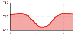
Route length: 2.3 km
Duration: 1:30 h

Trail Nr.: 65

Tour information

  • Requirement: medium
  • Length: 2.3 km
  • Duration: 1:30 h
  • Elevation uphill:72 hm
  • Elevation downhill:72 hm
Highest point702 m

Starting point

Tourist Office Schwendt

Finishing point

Tourist Office Schwendt

Features

  • Circular route
  • Suitable for families

Best time of year

  • January
  • February
  • March
  • April
  • May
  • June
  • July
  • August
  • September
  • October
  • November
  • December

Trail condition

Asphalt, gravel

Equipment

Breathable outdoor clothing suitable for the weather, sturdy footwear, food (snacks, drinks),
sun protection (sunglasses, sun cream & cap), rain protection, cash; guest card if using the bus
Source: TVB Kaiserwinkl

Description

The route starts at the parking lot by the information point (near Mairwirt). From there, follow the main road toward Kössen until you reach Lettenbauern; turn left here onto a forest trail toward Hasenberg. Just before reaching Hasenberg, turn right over a bridge and through the forest to the Aschental farmhouse. Follow the trail past Stelzerhof, then turn right back to the starting point.

Getting here

  • Arrival by public transport

    By bus to the stop Schwendt Dorf

  • Parking

    In the centre of Schwendt

Weather

Today

clear sky
35°C/14°C
0%0.2l5 km/h

Fri

light rain showers
35°C/13°C
50%3.1l5 km/h

Sat

light rain showers
28°C/16°C
70%10.3l5 km/h
Go to weather forecast

More tours in the surrounding area

Newsletter

The mountain is calling? So does our newsletter!

In our monthly newsletter we reveal the best holiday tips for Tyrol.