

Opening hours:Today closed
Place:Obertilliach
:Restaurant
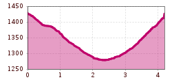
Sunny winter hiking trail from Obertilliach through the Tilliacher Feldflur to the "Möser" and back.

Basic equipmentformountainhikingincludessturdy hiking bootswith a goodtread, a 30-35 literbackpack, and functionalclothingbased on thelayeringprinciple, includingsufficient spare clothes. Essential itemsare rain, cold, and sunprotection, adequatefluids and food, aswellas a first-aid kit and a charged mobile phone. A mapor a GPS devicesupportsorientation.
The informationservesas a guideline and does not claimtobe exhaustive. Equipment mustalwaysbeadaptedtothe planned route, weatherconditions, season, naturalhazards, environmental influences, and personal needs.
Starting on the southern side of the village centre, the Mösernrunde takes a pleasant route through the Möser along the Bachhäuselbach stream towards Bergen. After crossing the Bachhäuselbach stream, you return to the centre of Obertilliach.


