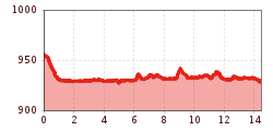
DescriptionThe Fitness Run route is 14,5km and 54m in elevation on flat gravel and asphalt paths from Pertisau to Achenkirch.
Stage of the Berliner Höhenweg (Zillertal Runde): Berliner Hütte - Greizer HütteDifficulty: difficult Length: 10.2 km Duration: 6:30 h Elevation uphill: 1,200 m See trailSee trail: Stage of the Berliner Höhenweg (Zillertal Runde): Berliner Hütte - Greizer Hütte
Stage of the Berliner Höhenweg (Zillertal Runde): Greizer Hütte - Kasseler HütteDifficulty: difficult Length: 9.8 km Duration: 6:00 h Elevation uphill: 650 m See trailSee trail: Stage of the Berliner Höhenweg (Zillertal Runde): Greizer Hütte - Kasseler Hütte
Großer MutzkopfDifficulty: easy Length: 10.3 km Duration: 4:00 h Elevation uphill: 507 m See trailSee trail: Großer Mutzkopf
Kaser circuit: adaptive cross-country skiing trail in the Kaunertal ValleyOpening hours: closed Difficulty: easy Length: 1.0 km Elevation uphill: 10 m : Style: Skating, Classic Go to Cross-country skiing trailGo to Cross-country skiing trail: Kaser circuit: adaptive cross-country skiing trail in the Kaunertal Valley
3-Länder TrailOpening hours: open Difficulty: medium Length: 3.4 km Go to biketourGo to biketour: 3-Länder Trail
Plamort TrailOpening hours: open Difficulty: Very easy Length: 2.5 km Go to biketourGo to biketour: Plamort Trail
Hike via Nördlinger Hütte to Reither SpitzeDifficulty: difficult Length: 9.9 km Duration: 7:30 h Elevation uphill: 1,191 m See trailSee trail: Hike via Nördlinger Hütte to Reither Spitze
JuifenalmDifficulty: easy Length: 9.5 km Duration: 4:18 h Elevation uphill: 585 m See trailSee trail: Juifenalm
Marmot TrailOpening hours: open Difficulty: easy Length: 573 m Duration: 0:20 h Elevation uphill: 12 m See trailSee trail: Marmot Trail
Nauders mountain trailDifficulty: medium Length: 18.0 km Duration: 7:00 h Elevation uphill: 407 m See trailSee trail: Nauders mountain trail
Kühtai - SulzkogelDifficulty: medium Length: 12.7 km Duration: 7:21 h Elevation uphill: 1,079 m See trailSee trail: Kühtai - Sulzkogel
Oberer Gerry TrailOpening hours: open Difficulty: medium Length: 1.2 km Go to biketourGo to biketour: Oberer Gerry Trail
3-hut hikeDifficulty: medium Length: 13.2 km Duration: 6:00 h Elevation uphill: 1,120 m See trailSee trail: 3-hut hike
491/492- Singletrail Isskogel (Iss-Flow 1-3)Opening hours: open Difficulty: easy Length: 400 m Duration: 0:08 h Elevation uphill: 1 m Go to biketourGo to biketour: 491/492- Singletrail Isskogel (Iss-Flow 1-3)
Faltegartenköpfl peakDifficulty: medium Length: 8.5 km Duration: 4:30 h Elevation uphill: 509 m See trailSee trail: Faltegartenköpfl peak
Stage Berliner Höhenweg (Zillertal Runde): Kasseler Hütte - EdelhütteDifficulty: difficult Length: 13.0 km Duration: 9:00 h Elevation uphill: 800 m See trailSee trail: Stage Berliner Höhenweg (Zillertal Runde): Kasseler Hütte - Edelhütte
Muhs panorama trailDifficulty: medium Length: 15.2 km Duration: 6:00 h Elevation uphill: 1,090 m See trailSee trail: Muhs panorama trail
495 - Singletrail Isskogel (495 Iss-Tough 1-2)Opening hours: open Difficulty: medium Length: 300 m Duration: 0:06 h Elevation uphill: 9 m Go to biketourGo to biketour: 495 - Singletrail Isskogel (495 Iss-Tough 1-2)
Lasörling altitude trailDifficulty: medium Length: 57.0 km Duration: 25:00 h Elevation uphill: 3,740 m See trailSee trail: Lasörling altitude trail
Venediger altitude trailDifficulty: difficult Length: 55.5 km Duration: 27:00 h Elevation uphill: 3,915 m See trailSee trail: Venediger altitude trail
Karwendelmarsch 52 kmDifficulty: difficult Length: 52.0 km Duration: 19:00 h Elevation uphill: 2,281 m See trailSee trail: Karwendelmarsch 52 km
Kaunergrat Circular Route - 3 DaysMore InformationMore Information: Kaunergrat Circular Route - 3 Days
The sunny plateau circuitDifficulty: easy Length: 33.0 km Duration: 8:00 h Elevation uphill: 740 m See trailSee trail: The sunny plateau circuit
Zams - Württemberger HausDifficulty: medium Length: 10.1 km Duration: 11:20 h Elevation uphill: 1,554 m See trailSee trail: Zams - Württemberger Haus
Bergdoktor-Winter Hiking TrailDifficulty: easy Length: 2.1 km Duration: 0:45 h Elevation uphill: 40 m Go to winter hikeGo to winter hike: Bergdoktor-Winter Hiking Trail
Give feedback for a chance to win a special holiday experience!Click here for the surveyClick here for the survey
 Berliner Hütte - Greizer Hütte")
 Greizer Hütte - Kasseler Hütte")

")
.jpg")


 Kasseler Hütte - Edelhütte")


