
Road bike tour Bike Trail Tirol

closed
St. Anton am Arlberg /
Difficulty ratings: medium
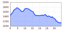
Route length: 35.1 km
Duration: 3:00 h

Tour information

  • Requirement: medium
  • Length: 35.1 km
  • Duration: 3:00 h
  • Elevation uphill:753 hm
  • Elevation downhill:0 hm
Highest point1,804 m

Starting point

St. Anton am Arlberg

Finishing point

St. Anton am Arlberg

Equipment

drinks/snacks, rain jacket, sun protection
Source: TVB St Anton am Arlberg

Description

This 35-kilometer long route travels always on asphalt trails, featuring some 350 meters of altitude gain. Right at the beginning you have to conquer the steepest part, leading up to Arlberg Pass. Beautiful insights and breathtaking views accompany you all day long.

Getting here

  • Parking

    The best way to get to St. Anton am Arlberg is explained on our website: www.stantonamarlberg.com/en/service/travel From the first day of your vacation in our region, you will get the St. Anton Sommer-Card, which includes free and unlimited use of all operating bus lines between Landeck and St. Christoph (local bus, hiking bus, Verwall bus, regular bus lines from St. Christoph to Landeck). For further information about the St. Anton Sommer-Card vist: www.sommerkarte.at/en/the-summer-card.html

More tours in the surrounding area

  • Bikepacking Tour Tyrol - Tour Overview

    Difficulty:difficult
    Length:413.0 kmDuration:5 daysElevation uphill:6,600 m
  • Bikepacking Tour Tyrol - Stage 1

    Difficulty:difficult
    Length:83.0 kmDuration:6:37 hElevation uphill:1,210 m
  • Heilbronner Hütte 796

    Opening hours:closed
    Difficulty:difficult
    Length:39.0 kmDuration:4:30 hElevation uphill:1,071 m
  • Darmstädter Hütte

    Opening hours:closed
    Difficulty:difficult
    Length:25.5 kmDuration:4:00 hElevation uphill:1,110 m
Newsletter

The mountain is calling? So does our newsletter!

In our monthly newsletter we reveal the best holiday tips for Tyrol.
