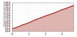
The route starts at the Rinner Alm hiking parking lot and goes uphill on a forest road. Past the ice skating rink, you reach the Rinner Alm (1,394 m) through switchbacks in the forest.
Open interactive mapOpen this POI on the interactive mapElevation profiledownloadRinner Alm MTB Route 518.gpx
The Neue Magdeburger Hütte - MTB route (543)Difficulty:difficultLength:16.3 kmDuration:3:24 hElevation uphill:1,001 mGo to biketourGo to biketour: The Neue Magdeburger Hütte - MTB route (543)
The Chainless OneDifficulty:easyLength:7.6 kmDuration:0:10 hGo to biketourGo to biketour: The Chainless One
The Arzler Alm Trail (5007)Difficulty:mediumLength:3.8 kmDuration:0:15 hGo to biketourGo to biketour: The Arzler Alm Trail (5007)
The Hungerburg Trail (596)Difficulty:difficultLength:550 mDuration:0:15 hGo to biketourGo to biketour: The Hungerburg Trail (596)
Innsbruck to KühtaiDifficulty:difficultLength:110.0 kmDuration:4:30 hElevation uphill:1,600 mGo to biketourGo to biketour: Innsbruck to Kühtai
The First OneDifficulty:mediumLength:2.4 kmDuration:0:15 hGo to biketourGo to biketour: The First One
The Rough OneDifficulty:difficultLength:2.0 kmDuration:0:10 hGo to biketourGo to biketour: The Rough One
Give feedback for a chance to win a special holiday experience!Click here for the surveyClick here for the survey