
Opening hours:open
Place:Kössen
:Restaurant
Demanding route, steeper climbs, gravel and tarmac roads
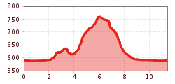
From the soccer field over the Achendamm to the Hüttwirt, over the Hüttwirt bridge and onto the Blaik, right over the Kräutl to Kaltenbach, left on towards the Peternhof, at the Hacklbauern onto the road, left on to the Hinhagerhof, then left onto the footpath Kössen (Faistental), Blaik, over the Hüttwirt bridge, right on the Achendamm back to the soccer field.
Bus stop Waidach in Kössen Line 4030
Car park football pitch in Kössen or VZ Kaiserwinkl


alexandraerhart-27.jpeg")


.jpg")

.jpg")
.jpg")
 Mirja Geh (26).jpg")


.jpg")


