Mountain hikes Pyramidenspitze - Vorderkaiserfelden Nr. 90,91,95,811,49

Walchsee / Kaisergebirge
Difficulty ratings: difficult
Route length: 17.6 km
Duration: 9:00 h

Trail Nr.: 90, 91, 95, 811,49

Tour information

  • Requirement: difficult
  • Length: 17.6 km
  • Duration: 9:00 h
  • Elevation uphill:1,665 hm
  • Elevation downhill:1,665 hm
Highest point1,999 m

Starting point

Parking lot Hochberg Durchholzen

Finishing point

Parking lot Hochberg Durchholzen
  • Fitness level 6 / 6
  • Technique 6 / 6

Features

  • Circular route

Best time of year

  • January
  • February
  • March
  • April
  • May
  • June
  • July
  • August
  • September
  • October
  • November
  • December

Trail condition

Meadow, forest, and rocky trail

Equipment

Breathable outdoor clothing suitable for the weather, sturdy footwear, food (snacks, drinks),
sun protection (sunglasses, sun cream & cap), rain protection, cash; guest card if using the bus
Source: Kaiserwinkl

Description

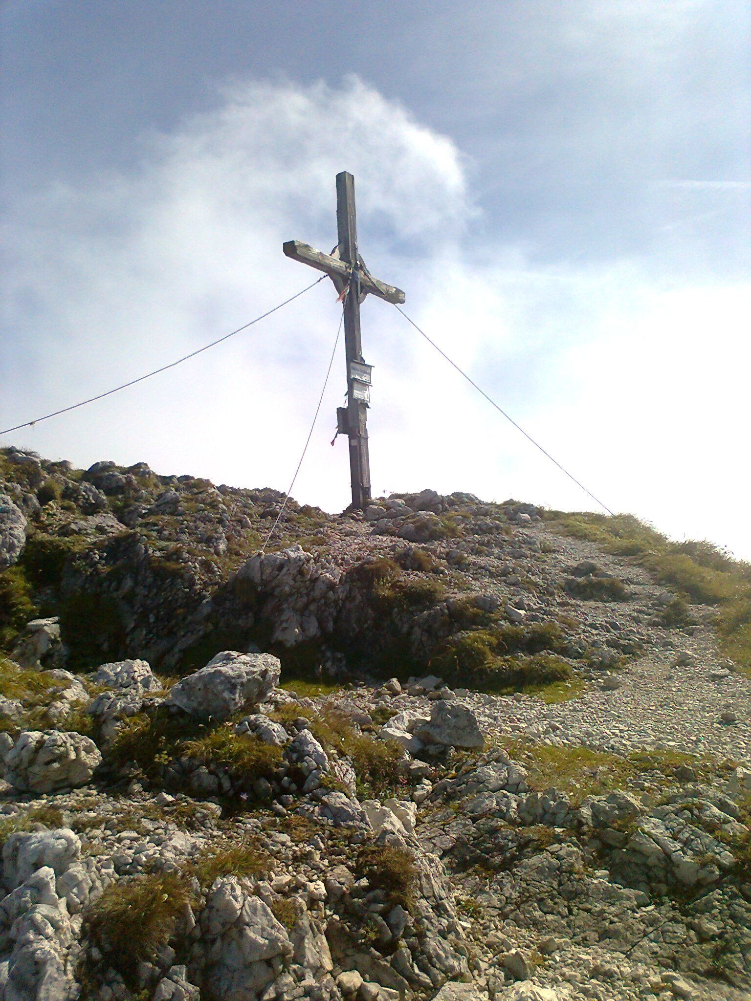
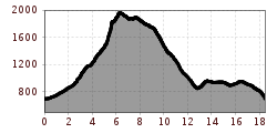
From Walchsee / Durchholzen along the Achentaler Bach over Kotlacken and Großpointeralm to first crossroads with bench. Here we branch off to the left, pass the Winkelalm and climb into the Winkelkar up to the rocks. This is where the via ferrata (B and 1-), partially secured by wire ropes, begins, leading us northeast to the ridge and then to the south via an iron-clad rock platform to the panoramic summit of the Pyramid peak (summit cross and summit book). The descent leads via Latschenfelder to Petersköpfl and Vorderkaiserfeldenhütte. From the hut on the Musikantensteig to Gasthof Köllnberg and continue to Aschingeralm. Shortly before the Aschingeralm to the middle station of the lift Zahmer Kaiser and the forest road follow back to the starting point.

Getting here

  • Arrival by public transport

    By bus, take line 4030 to the 'Durchholzen' stop.

  • Parking

    Parking at the Zahmer Kaiser parking lot

More tours in the surrounding area

  • Burgeralm

    Difficulty: medium
    Length: 13.8 km Duration: 6:00 h Elevation uphill: 974 m
  • Brennkopf

    Difficulty: medium
    Length: 8.6 km Duration: 4:00 h Elevation uphill: 738 m
Newsletter

The mountain is calling? So does our newsletter!

In our monthly newsletter we reveal the best holiday tips for Tyrol.