Hiking

The most beautiful panoramic trails in Tyrol

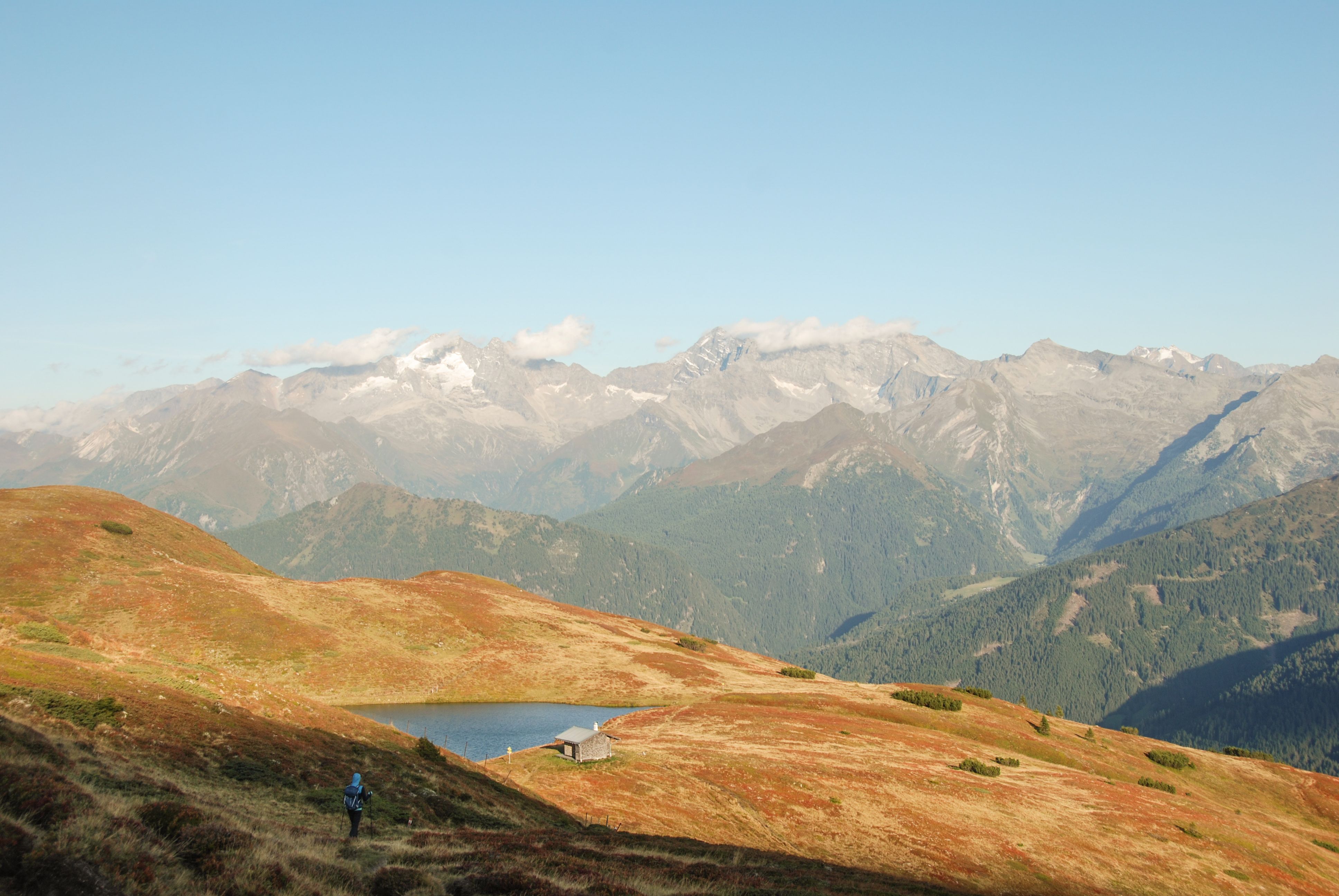
What makes hiking on panoramic trails in autumn so special? The uninterrupted views into the distance, of course! The following panoramic trails are perfect for an autumn hike in September or October. Hike for hours in the clear autumn air on high-altitude trails through autumnal nature and identify and count the Tyrolean peaks in the distance. - One of our favourite activities in Tyrol.
    • Difficultymedium
    • Length13.0 km
    • Duration3:30 h
    • Elevation uphill834 m
    • PlaceSteinach / Stubaier Alpen
  • Easy ridge hike over several easy peaks
  • far-reaching views of the Stubai and Tux Alps
  • Lichtsee: a dream place to linger
More Information
    • Difficultymedium
    • Length11.3 km
    • Duration4:00 h
    • Elevation uphill370 m
    • PlaceTelfes im Stubaital / Stubaier Alpen
  • High trail with views of all the famous peaks of the Stubai Alps
  • "Gletscherblick" natural spectacle: one of the best vantage points in the valley
  • Several mountain huts and the Starkenburger Hütte along the way
More Information
    • Difficultydifficult
    • Length5.2 km
    • Duration5:00 h
    • Elevation uphill344 m
    • Place / Karwendel
  • Aeroplane view of Innsbruck and the Inn Valley
  • Exciting contrasts between the Karwendel wilderness and the urban Inntal valley
  • one of the best Brettljausen in Tyrol at the Pfeishütte
More Information
    • Difficultymedium
    • Length16.0 km
    • Duration8:30 h
    • Elevation uphill1,200 m
    • PlaceMariastein / Brandenberger Alpen (Rofan)
  • Two easily accessible summits with beautiful low and distant views
  • relatively low lying and usually still sunny and snow-free late in autumn
  • with the Buchackeralm and Höhlensteinhaus, two great places to stop for refreshments along the way
More Information
    • Difficultydifficult
    • Length16.9 km
    • Duration9:00 h
    • Elevation uphill1,390 m
    • PlaceSt. Leonhard im Pitztal / Ötztaler Alpen
  • absolute dream route for experienced and fit climbers
  • the jagged Kaunergrat always in view
  • one cirque floor is more beautiful than the next
More Information
    • Difficultymedium
    • Length14.8 km
    • Duration6:30 h
    • Elevation uphill760 m
    • PlaceWildschönau / Kitzbüheler Alpen
  • the hiking highlight in the Wildschönau with four relatively easy peaks
  • several alpine pastures along the way and the Schönanger show dairy at the very end
  • In autumn, boundless views across the Kitzbühel Alps
More Information
    • Difficultyeasy
    • Length7.0 km
    • Duration2:30 h
    • Elevation uphill200 m
    • PlacePatsch / Tuxer Alpen
  • Easy high-altitude hike with views of the Inn Valley and the Karwendel directly opposite
  • Path through one of the largest and oldest Swiss stone pine forests in Europe
  • easily accessible by public transport
More Information
    • Difficultyeasy
    • Length4.1 km
    • Duration1:30 h
    • Elevation uphill195 m
    • PlaceAlpbach / Kitzbüheler Alpen
  • Easy family hike with few metres in altitude and easy summit ascent
  • magnificent views far beyond the Alpbach mountains
  • Hike can be combined with a visit to Lauserland and the Lauser Sauser summer toboggan run
More Information
    • Difficultymedium
    • Length15.2 km
    • Duration6:00 h
    • Elevation uphill1,090 m
    • PlacePrägraten am Großvenediger / Venedigergruppe
  • Insider tip in the quiet East Tyrolean Virgental Valley
  • Two marvellous places to stop for refreshments: the Berger See hut right by the lake and the Lasnitzen hut with views of the Großvenediger
  • great viewing point Zopanitzenalm with a view of the entire Venediger group
More Information
    • Difficultymedium
    • Length6.2 km
    • Duration2:40 h
    • Elevation uphill300 m
    • PlaceWörgl / Ötztaler Alpen
  • High-altitude trail with little difference in altitude on the sunny slope of the Kaunertal
  • Continuous views of the wild rocky peaks of the Kaunergrat ridge
  • Two alpine pastures and dream spot Knottenkino at the Aifneralm
More Information
    • Difficultymedium
    • Length6.6 km
    • Duration3:00 h
    • Elevation uphill475 m
    • PlaceBach-Stockach / Allgäuer Alps
  • Sunny ridge hike over the "Mutte" with mountain railway support
  • View over the entire Lechtal valley and the Allgäu and Lechtal Alps
  • Stop off at the Bernhardseckhütte in a wonderful panoramic location
More Information
    • Difficultymedium
    • Length24.4 km
    • Duration9:45 h
    • Elevation uphill1,263 m
    • PlaceLeutasch / Wetterstein-Gebirge and Mieminger Kette
  • Long and challenging dream route on the south side of the Wetterstein mountains
  • Seven mountain pastures along the way
  • Impressive close-up views of the southern slopes of the Wetterstein and far-reaching views as far as the main ridge
More Information
    • Difficultymedium
    • Length7.2 km
    • Duration5:00 h
    • Elevation uphill580 m
    • PlaceJerzens im Pitztal / Ötztaler Alpen
  • Wonderful panoramic tour with cable car support
  • sweeping views across the Inntal valley into the Northern Limestone Alps and southwards into the Ötztal Alps
  • with the Hochzeiger a challenging summit and the Kalbenalm a charming place to stop for refreshments
More Information
    • Difficultymedium
    • Length13.6 km
    • Duration6:00 h
    • Elevation uphill980 m
    • PlaceGoing am Wilden Kaiser / Kaisergebirge
  • Circular trail full of natural highlights at the southern foot of the Wilder Kaiser
  • Schleierwasserfall power spot and climbing hotspot
  • Refreshment stops at Gaudeamushütte and Obere Regalm
More Information
  • Varied route high above the Tannheimer Tal
  • Bad Kissinger Hütte: refreshment stop in a dream location on the striking Aggenstein
  • also possible with cable car support until late autumn
More Information

More about panoramic trails

Newsletter

The mountain is calling? So does our newsletter!

In our monthly newsletter we reveal the best holiday tips for Tyrol.