Hut Otto-Mayr-Hütte

Musau

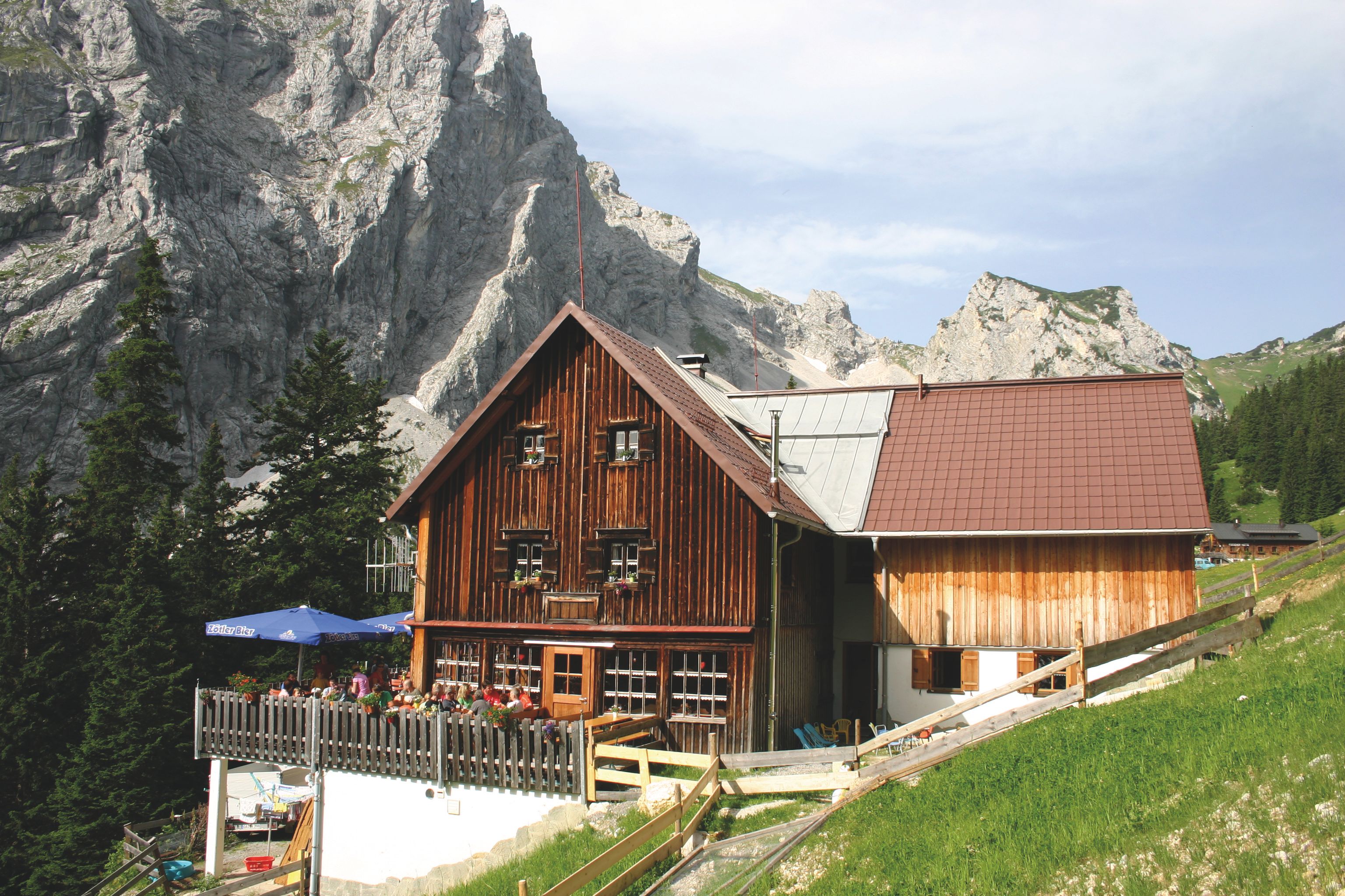
The Otto-Mayr-Hütte (1,530 metres) is a mountain refuge in the Allgäu Alps offering walkers and hikers in the Tannheim Mountains a place to rest and enjoy a hearty meal.

Information

Altitude

1,530 m

Mountain range

Allgäu Alps

Sleeps (number of guests)

  • Dormitory/beds:41
  • Dormitory with mattresses:19

Facilities

  • Showers

Suitable for:

  • mountain hiking
  • Rock climbing
  • Mountain bike
  • Ski touring

Coordinates

  • Geographic length:10.618611111111
  • Geographic width:47.509444444444
  • UTM (east):5263036
  • UTM (east):621894
  • Reference Meridian:
Source: Alpenverein

Description

Mountain refuge for daytrippers and climbers
German Alpine Club, Augsburg DIvision

The lush Tannheimer Tal Valley and craggy mountain peaks rising above provide a spectacular backdrop to the Otto-Mayr-Hütte, a mountain refuge at the end of the Reintal Valley in the Tannheim Mountains. The surrounding area is ideal for long hikes through the green meadows as well as challenging rock climbing on sheer pitches, making it popular with families, hikers and mountaineers. The food is hearty and the accommodation (a mixture of rooms and dormitories) is cosy. There is a separate room for dogs. The hut is open from May until October. The hut is not far from the Willi-Merkl-Gedächtnishütte, a self-catering hut.

How to get to the Otto-Mayr-Hütte

From Musau in 2.5 hours, from Grän via Füssener Jöchl cable car in 1 hour, from Vils in 3.5 hours, from Nesselwängle in 4.5 hours

Walks and hikes in the area (walking time to summit)

Große Schlicke (2,059 metres), 1.75 hours, intermediate
Köllenspitze (2,238 metres), 3.5 hours, difficult
Rote Flüh (2,108 metres), 2.5 hours, difficult
Gimpel (2,176 metres), 3.5 hours, difficult

Further huts in the area

Gimpelhaus, 2 hours
Bad Kissinger Hütte, 3 hours
Tannheimer Hütte, 3 hours
 

Getting here

Nearby huts

  • Schüsselkar-Biwak

    Place:Wetterstein / Mieminger Mountains
    :2,536 m
  • Siegerlandhütte

    Place:Stubai Alps
    :2,710 m
    :Suitable formountain hikingHigh-altitude hikesRock climbingSki touring
  • Karlsbader Hütte

    Place:Gailtal Alps
    :2,260 m
    :Suitable formountain hikingRock climbingMountain bike
  • Spitzsteinhaus

    Place:Chiemgau Alps
    :1,252 m
    :Suitable formountain hikingMountain bikeSki touring
  • Kaunergrathütte

    Place:Ötztal Alps
    :2,817 m
    :Suitable formountain hikingHigh-altitude hikesRock climbingSki touring
  • Kellerjochhütte

    Place:Tux Alps
    :2,237 m
    :Suitable formountain hikingSki touring
  • Stüdlhütte

    Place:Glockner Mountains
    :2,801 m
    :Suitable forHigh-altitude hikesRock climbingSki touring
  • Sudetendeutsche Hütte

    Place:Granatspitz Mountains
    :2,650 m
    :Suitable formountain hikingHigh-altitude hikesRock climbingSki touring
  • Lamsenjochhütte

    Place:Karwendel Mountains
    :1,953 m
    :Suitable formountain hikingRock climbing
  • Leutkircher Hütte

    Place:Lechtal Alps
    :2,251 m
    :Suitable formountain hikingSki touring
  • Lienzer Hütte

    :1,977 m
    :Suitable formountain hikingHigh-altitude hikesRock climbingMountain bike
  • Lizumer Hütte

    Place:Tux Alps
    :2,019 m
    :Suitable formountain hikingSki touring
  • Vernagthütte

    Place:Ötztal Alps
    :2,755 m
    :Suitable formountain hikingHigh-altitude hikesRock climbingSki touring
  • Martin-Busch-Hütte

    Place:Ötztal Alps
    :2,501 m
    :Suitable formountain hikingHigh-altitude hikesMountain bikeSki touring
  • Meißner Haus

    Place:Tux Alps
    :1,720 m
    :Suitable formountain hikingMountain bikeSki touring
  • Westfalenhaus

    Place:Stubai Alps
    :2,273 m
    :Suitable formountain hikingHigh-altitude hikesSki touring
  • Winnebachseehütte

    Place:Stubai Alps
    :2,372 m
    :Suitable formountain hikingRock climbingSki touring
Newsletter

The mountain is calling? So does our newsletter!

In our monthly newsletter we reveal the best holiday tips for Tyrol.