Alpine Association huts Stuttgarter Hütte

The Stuttgarter Hütte (2,310 metres) is a German Alpine Club mountain refuge is an easy-to-reach hut in the Lechtal Alps on the border between Tirol and Vorarlberg.

Information

Altitude

2,310 m

Mountain range

Lechtal Alps

Sleeps (number of guests)

  • Dormitory/beds:22
  • Dormitory with mattresses:20

Facilities

  • Showers
  • Mobile phone reception

Suitable for:

  • mountain hiking
  • Rock climbing
  • Mountain bike

Coordinates

  • Geographic length:10.204722222222
  • Geographic width:47.180277777778
  • UTM (east):5225909
  • UTM (east):591274
  • Reference Meridian:
Source: Alpenverein

Description

Mountain hut on the Lech Valley High Trail
German Alpine Club, Schwaben Division

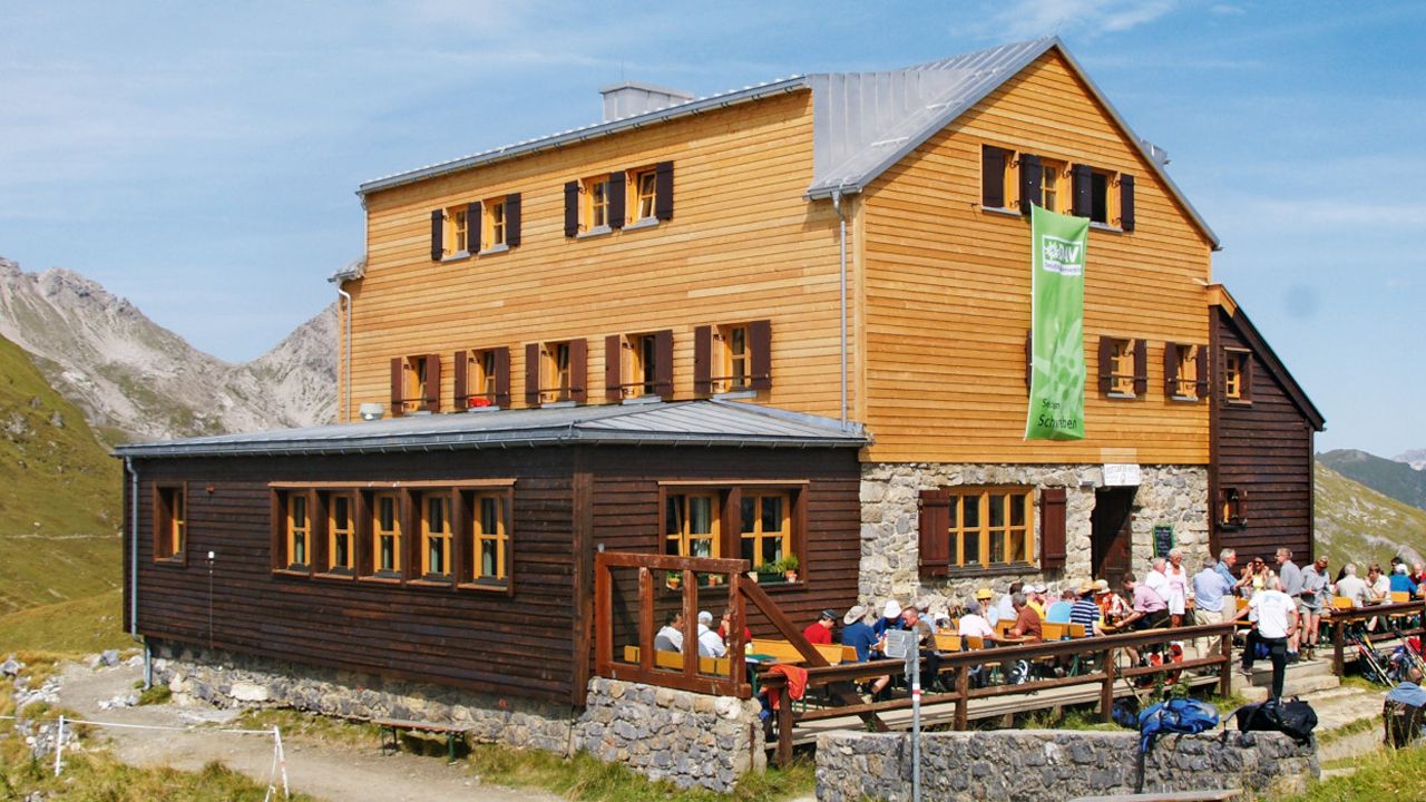
The Stuttgarter Hütte's appearance alone perfectly combines the past with the present, helped not least by some sophisticated renovation work. The hut, you see, is really rather old. It was built in 1910 just south of the Krabachjoch ridge, pretty much exactly on the border between Tirol and Vorarlberg, at an altitude of 2,310 metres. It can get quite stormy here, which is why the mountain refuge has suffered damage several times. It is has been repaired every time, much to the delight of the hikers and climbers who are always served very well here. The surrounding mountains contain hikes and climbs for all abilities, including families with children. The hut has showers and mobile phone reception.

How to get to the Stuttgarter Hütte

From Lech [am Arlberg] via Rüfikopf (cable car) and Rauhekopfscharte in 2.5 hours, from Zürs [am Arlberg] in 2 hours, from Lech via Wösterjoch and Rauhekopfscharte in 4.5 hours, from Steeg im Lechtal through Krabachtal Valley in 5 hours, from Kaisers through Almajurtal Valley in 4.5 hours

Walks and hikes in the area (walking time to summit)

Fanggekarspitze (2,640 metres), 1.5 hours, intermediate
Erlispitze (2,634 metres), 1 hour, intermediate
Valluga (2,809 metres), 2.5 hours, difficult
Rüfispitze (2,632 metres), 3.5 hours, difficult
Arlberg via ferrata, 5 hours, climbing sections rated up to D - difficult

Further huts in the area, long-distance hiking trails

Leutkircher Hütte, 4 hours
Ulmer Hütte, 4 hours
Edelweißhaus, 4 hours

The Stuttgarter Hütte is located on the Lech Valley High Trail.

Getting here

Nearby huts

  • Kalser Tauernhaus

    Place: Glockner Mountains
    : 1.8 km
    : Suitable for mountain hikingHigh-altitude hikesRock climbing
  • Kasseler Hütte

    Place: Zillertal Alps
    : 2.2 km
    : Suitable for mountain hikingHigh-altitude hikes
  • Konstanzer Hütte

    Place: Verwall Mountains
    : 1.7 km
    : Suitable for mountain hikingHigh-altitude hikesRock climbingMountain bikeSki touring
  • Ludwigsburger Hütte

    Place: Ötztal Alps
    : 1.9 km
    : Suitable for mountain hikingHigh-altitude hikesMountain bikeSki touring
  • Memminger Hütte

    Place: Lechtal Alps
    : 2.2 km
    : Suitable for mountain hikingHigh-altitude hikesRock climbing
  • Nauderer Hütte

    Place: Ötztal Alps
    : 1.9 km
    : Suitable for alpine skiingmountain hikingMountain bikeSki touring
  • Neue Reichenberger Hütte

    Place: Venediger Mountains
    : 2.6 km
    : Suitable for mountain hikingHigh-altitude hikesRock climbingMountain bike
  • Oberlandhütte

    Place: Kitzbühel Alps
    : 1.0 km
    : Suitable for alpine skiingmountain hikingcross country skiingMountain bikeSki touring
  • Olpererhütte

    Place: Zillertal Alps
    : 2.4 km
    : Suitable for mountain hikingHigh-altitude hikesRock climbing
  • Grünseehütte

    Place: Granatspitz Mountains
    : 2.2 km
    : Suitable for mountain hikingMountain bikeSki touring
  • Pforzheimerhütte

    Place: Stubai Alps
    : 2.3 km
    : Suitable for mountain hikingHigh-altitude hikesRock climbingMountain bikeSki touring
  • Gufferthütte

    Place: Rofan Mountains
    : 1.5 km
    : Suitable for mountain hikingRock climbingMountain bikeSki touring
  • Potsdamer Hütte

    Place: Stubai Alps
    : 2.0 km
    : Suitable for mountain hikingHigh-altitude hikesMountain bikeSki touring
  • Ramolhaus

    Place: Ötztal Alps
    : 3.0 km
    : Suitable for High-altitude hikes
  • Hanauer Hütte

    Place: Lechtal Alps
    : 1.9 km
    : Suitable for mountain hikingRock climbingSki touring
  • Rauhekopfhütte

    Place: Ötztal Alps
    : 2.7 km
    : Suitable for mountain hikingHigh-altitude hikesSki touring
  • Heidelberger Hütte

    Place: Silvretta Alps
    : 2.3 km
    : Suitable for mountain hikingHigh-altitude hikesRock climbingMountain bikeSki touring
  • Hochwildehaus

    Place: Ötztal Alps
    : 2.9 km
    : Suitable for High-altitude hikesSki touring
  • Hohenzollernhaus

    Place: Ötztal Alps
    : 2.1 km
    : Suitable for mountain hikingHigh-altitude hikesRock climbingSki touring
Newsletter

The mountain is calling? So does our newsletter!

In our monthly newsletter we reveal the best holiday tips for Tyrol.