Measuring at least 85 kilometres in length and generally staying at between 2,000 and 2,500 metres above sea level, the Lech High Trail is an outdoor adventure for fit and experienced mountaineers in search of a challenge. The route follows the main ridge of the Lechtal Alps and is divided up into 18 stages which can be completed in anywhere between 10 and 19 days depending on individual fitness levels. The shortest of the several variations available has 7,000 vertical metres of climbing and descending along technical trails.Along the way there are 13 huts run by the Austrian Alpine Club offering not only accommodation but also hearty food and good company in the evenings. The biggest attraction from a landscape perspective is the Steinsee lake, a shimmering green-blue pearl located to the east of the Steinseehütte hut in a natural rock amphitheatre capped by the imposing Dremlscharte ridge. The Lechtal High Trail is part of the North Alpine Long-Distance Trail 01 and the European Hiking Trail E4. Most of the route leads through high alpine terrain. That means hikers must be fit, experienced in the mountains, sure-footed, not afraid of heights and familiar with the basics of rock climbing. Depending on the snow conditions, some stages of this hike may require a rope, ice pick and crampons. Among the trickiest sections is the Roßkarscharte ridge between the Steinseehütte and the Württemberger Haus huts and the traverse of the south-eastern face of the Vorderseespitze mountain between the Ansbacher Hütte and Kaiserjochhaus huts.

Long-Distance Hike

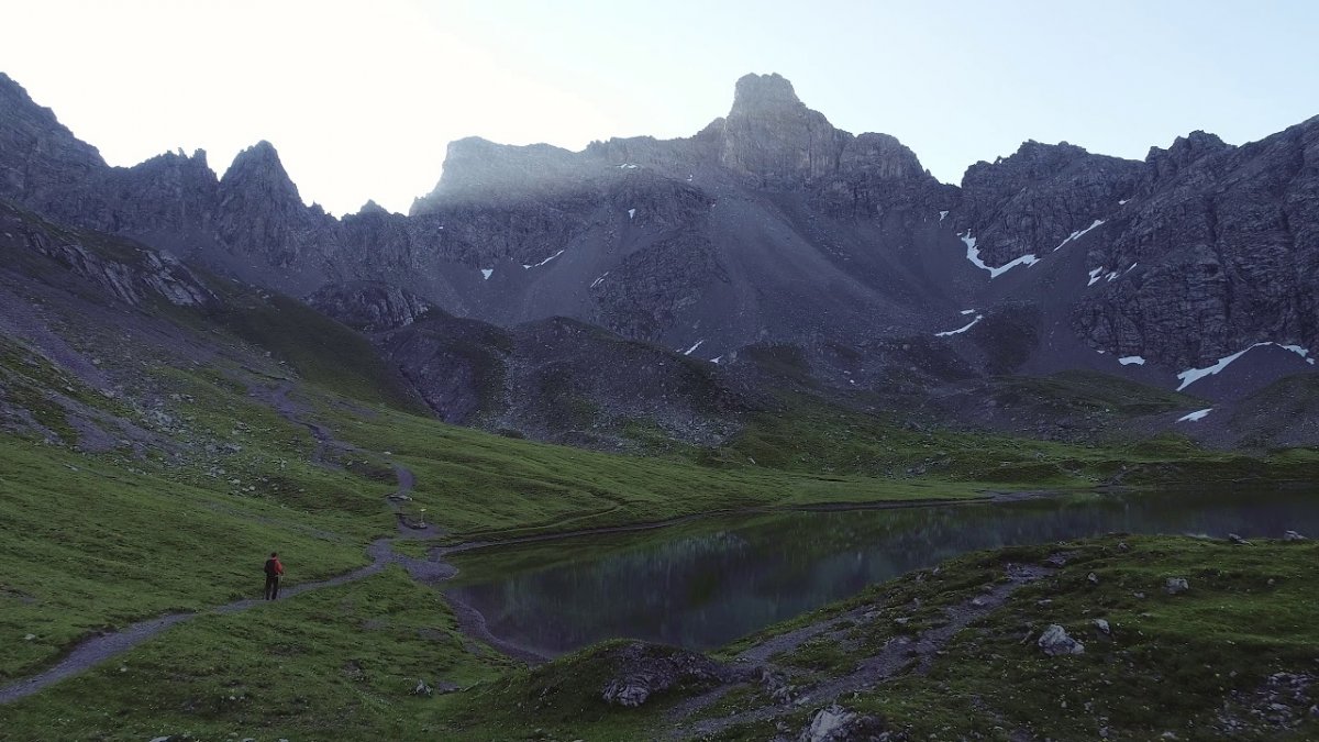
"Wild, majestic and powerful are some of the best words to describe the Lechtal High Trail. One of the undoubted highlights is the natural amphitheatre around the Steinsee lake."
Irene Rapp, nature editor at the "Tiroler Tageszeitung" newspaper


Starting point
Steeg (Lechtal Valley) / Stuttgarter Hütte hut
Finishing point
Anhalter Hütte hut / Elmen (Lechtal Valley)
Mountain chain
Lechtal Alps
Length
85 km
Duration
18 day(s)
Features
- Wheelchair-accessible Hiking Route
- Circular hike
Difficulty rating
difficult (black trails)
Altitude
2,630m 1,198m
Elevation uphill 6,950m
Vertical metres downhill 6,736m
Fitness level
Technique
Best time of year
Jan
Feb
Mar
Apr
May
Jun
Jul
Aug
Sep
Oct
Nov
Dec
* These are approximate values and recommendations. Please take your personal fitness level, technical ability and the current weather conditions into account. Tirol Werbung cannot guarantee that the information provided is correct and accepts no liability.
Parking
"Aqua Nova" swimming pool in Steeg or at the "Sägewerk Prenten" sawmill
Places serving food & drink
Ascent from the valley: Stuttgarter Hütte
Stage 1: Leutkircher Hütte
Stage 2: Ulmer Hütte
Stage 3: Leutkircher Hütte
Stage 4: Kaiserjochhaus
Stage 5: Ansbacher Hütte
Stage 6: Frederic-Simms-Hütte
Stage 7: Ansbacher Hütte
Stage 8: Memminger Hütte
Stage 9: Augsburger Hütte
Stage 10: Memminger Hütte
Stage 11: Württemberger Haus
Stage 12: Steinseehütte
Stage 13: Württemberger Haus
Stage 14: Hanauer Hütte
Stage 15: Hanauer Hütte
Stage 16: Steinseehütte
Stage 17: Muttekopfhütte
Stage 18: Anhalter Hütte
Trail description
Ascent from the valley: Steeg (Lechtal Valley) – Stuttgarter Hütte (2,305m)
Uphill/downhill: 1,166/61 vertical metres, walking time: 5.5 hours, distance: 12.4 kilometres, difficulty: intermediate
The ascent to the Stuttgarter Hütte hut is best tackled from the Lechtal Valley. Hikers can either leave from the village of Steeg or take the bus to the "Bockbach/Krabach" bus stop. From the bus stop, head south through the Krabachtal Valley and up onto the Krabachjoch ridge with the Stuttgarter Hütte hut perched at the top.
Stage 1: Stuttgarter Hütte (2,305m) – Leutkircher Hütte (2,261m)
Uphill/downhill: 578/619 vertical metres, walking time: 4 hours 15 minutes, distance: 8.8 kilometres, difficulty: difficult
The Lechtal High Trail starts at the Stuttgarter Hütte, located atop the Krabachjoch ridge in the Lechtal Alps. From the hut, walk eastward to the 2,430m Erlijoch ridge located between the twin summits of Erlispitze and Fanggekarspitze. Continue walking past Erlachalpe in the Almajurtal Valley, skirting below the summit of the Valluga mountain, to get to the Stapfe-Tobel gorge. This section can be treacherous in snow or adverse weather conditions and intimidating to inexperienced hikers. In early season and after heavy rainfall you may choose to opt for the alternative route past Erlachalpe and Bodenalpe. Check the current conditions and proceed accordingly. The day's hiking concludes at the Leutkircher Hütte.
Stage 2: Stuttgarter Hütte (2,305m) – Ulmer Hütte (2,288m)
Uphill/downhill: 418/439 vertical metres, hiking time: 3 hours, distance: 5.8 kilometres, difficulty: difficult
The stage from the Stuttgarter Hütte to the Ulmer Hütter is short but very enjoyable. Proceed along the Robert-Bosch-Weg trail to the Trittscharte ridge (2,580m). Catch your breath and scan the horizon dominated by the mighty peaks of the Silvretta and Verwall mountain ranges, including the 3,056-metre-high Patteriol. From the Trittscharte ridge, follow the trail down to the Ulmer Hütte, situated in the shadow of the iconic Valluga mountain. This popular shelter provides a hearty food and a good night’s sleep in comfy beds.
Stage 3: Ulmer Hütte (2,288m) – Leutkircher Hütte (2,261m)
Uphill/downhill: 464/488 vertical metres, walking time: 3.5 hours, distance: 7 kilometres, difficulty: difficult
As you travel from the Ulmer Hütte across the Matunjoch ridge (2,569m) and through the famous ski resort of St. Anton am Arlberg on Valluga mountain, the craggy and imposing Weißschrofenkamm accompanies you on your way. If you're feeling ambitious you may consider scaling the demanding via ferrata here, negotiating roughly 500 iron handholds and footholds as well as 1,050 iron staples and a 200-metre-long network of fixed steel cables firmly anchored into the rock. Hikers who opt to stay on the High Trail can look forward to some wonderful views on the rugged terrain just below the peaks of the Bacherspitzen mountains. Eventuall, after around three and a half hours of hiking, you will reach your base for the night: the Leutkircher Hütte on the Almajurjoch ridge.
Stage 4: Leutkircher Hütte (2,261m) – Kaiserjochhaus (2,310m)
Uphill/downhill: 327/279 vertical metres, walking time: 2 hours 10 minutes, distance: 4.4 kilometres, difficulty: difficult
This stage begins on the lush green slopes of the Stanskogel mountain. At 2,757 metres, this is the highest point on the High Trail. The ascent from the hut to the summit of the Stanskogel takes around an hour to complete. Hikers can then look forward to meadows dotted with colourful wildflowers set against the striking scenery of the jagged and craggy Lechtal Alps. Look over to the opposite valley to take in an excellent view of cloud-piercing, snow-covered 3,168m Hoher Riffler peak, which forms part of the Verwall mountain range. As the terrain on this short yet demanding walk becomes more rocky and wind-exposed you will soon reach the Kaiserjochhaus located deep in a sheltered hollow between the summits of Grießkopf and Bergleskopf mountains.
Stage 5: Kaiserjochhaus (2,310m) – Ansbacher Hütte (2,376m)
Uphill/downhill: 558/488 vertical metres, walking time: 4 hours, distance: 8.3 kilometres, difficulty: difficult
Follow the ridge-top track as it sidles south and north across cretaceous shale formations carpeted in vivid greenery. Eventually the trail meanders across the dolomite scree and talus slopes of Grießkopf mountain on its way up onto the Kridlonscharte ridge. There you are rewarded with a fine view of the Hintersee lake far below. From here the trail heads to the Hinterseejoch ridge and traverses the southern flank of the Vorderseespitze mountain on its way to the Alperschonjoch ridge (2,303m). This section of the has a network of cables anchored into the rock for you to hold onto. Another uphill section finally brings you atop the Flarschjoch ridge and on to the Ansbacher Hütte, the highest-lying hut in the Lechtal Alps.
Stage 6: Kaiserjochhaus (2,310m) – Frederic-Simms-Hütte (2,002m)
Uphill/downhill: 555/859 vertical metres, walking time: 4.5 hours, distance: 8 kilometres, difficulty: difficult
Leaving the Kaiserjochhaus heading eastward, the trail to the Frederic-Simms-Hütte branches off below the Hinterseejoch ridge. From here the trail runs northward. Having traversed the Kridlonkar ridge you’ll get to “Klämmle”, a short descent through a steep gully on the northern slope of Vorderseespitze mountain (permanently fixed cables are provided here for safety purposes). Below the reddish Feuerspitze mountain the trail climbs atop the Kälberlahnzugjoch ridge. From there the trail zigzags down to the Frederic-Simms-Hütte, tucked beneath a towering mountain, the 2,895-metre-high Holzgau Wetterspitze, which is one of the tallest peaks of the Lechtal Alps.
Stage 7: Frederic-Simms-Hütte (2,002m) – Ansbacher Hütte (2,376m)
Uphill/downhill: 892/519 vertical metres, walking time: 5 hours, distance: 7.9 kilometres, difficulty: difficult
From the Frederic-Simms-Hütte, retrace your steps to the Kälberlahnzugjoch ridge and take the left fork towards Stierlahnzugjoch (2,596m). The trail sidles below the rugged limestone faces of Feuerspitze mountain. Experienced hikers will want to climb the summit of the Feuerspitze, an ascent which takes roughly an hour but is not difficult. The Lech Valley High Trail traverses the north-eastern slopes of Vorderseespitze mountain and emerges onto the route coming from the Kaiserjochhaus at Knappenböden. From there, the route brings you to the Ansbacher Hütte.
Stage 8: Ansbacher Hütte (2.376m) – Memminger Hütte (2,242m)
Uphill/downhill: 888/1,024 vertical metres, walking time: 6 hours 15 minutes, distance: 10 kilometres, difficulty: difficult
This day trek takes you to Memminger Hütte, one of the most popular huts in the Lechtal Alps, offering 140 beds. Make your way across the Kopfscharte ridge, the Winterjöchl col and the Grießlscharte ridge. From there it’s down into the remote and pristine Parseiertal Valley towered over by the mighty 3,036-metre-high Parseierspitze, the highest peak in the Lechtal Alps. Having crossed the Parseierbach river, the trail continues climbing on its way up to the Memminger Hütte. Experienced hikers may want to climb the Parseierspitze, at 3,036m the highest summit in the Northern Limestone Alps.
Stage 9: Memminger Hütte (2,242m) – Augsburger Hütte (2,289m)
Uphill/downhill: 1,211/1,297 vertical metres, walking time: 8 hours, distance: 12 kilometres, difficulty: difficult
Crossing through the stunning Lechtal Alps’ wilderness, this rugged section follows the Augsburg High Trail and leads through the most beautiful and diverse surroundings along the Lechtal High Trail. Simply put, this is one of the most beautiful hikes in all of Tirol. On your way you’ll have to scale Winterjoch col (2,528m) and Parseierscharte ridge (2,604m), where there’s a bivouac (basic shelter) which you can use to stay overnight in case of an emergency. This grand tour of the Lechtal Alps further includes the Dawinscharte ridge (2,650m) and view-granting 2,968m Dawinkopf peak, the Lechtal Alps’ second-highest summit. The Augsburger Hütte has a stunning location perched atop the south flank of the Gatschkopf mountain.
Stage 10: Augsburger Hütte (2,289m) – Memminger Hütte (2,242m)
Uphill/downhill: 665/716 vertical metres, walking time: 4.5 hours, distance: 6.3 kilometres, difficulty: difficult
The peak-packed, view-granting and technical Spiehlerweg Trail links the Augsburger Hütte with Memminger Hütte. First, the trail reaches the Gatschkopf mountain (2,945m) and continues atop Patrolscharte ridge and Wegscharte ridge. Eventually you will reach secluded Seewiseen lakes. Tucked in a cleft high on the mountain, these little lakes enjoy an awesome setting. Hikers can gaze into the turquoise waters reflecting the sheer cliff faces spiraling to the heavens before completing the descent to the Memminger Hütte. This scramble section to the hut can be treacherous in snow or adverse weather conditions and may be intimidating to the unseasoned hiker. The footing is very loose in places, and rockfall is a real risk. Situated on the shores of sparkling Unterer Seewisee lake, the Memminger Hütte is flanked by rocky peaks.
Stage 11: Memming Hütte (2,242m) – Württemberger Hütte (2,220m) (the Württemberger Hütte is closed in 2024)
Uphill/downhill: 633/652 vertical metres, walking time: 4 hours 15 minutes, distance: 7 kilometres, difficulty: difficult
This stage begins with a ramble through flower-studded meadows – a multitude of blossoms proliferate along this walk on your way past the Unterer Seewisee lake. Shortly before reaching the Mittlerer Seewisee lake the trail branches off to Seescharte ridge (2,599m) and winds between rugged and rocky outcroppings before it traverses Großbergscharte ridge. Once aloft on the ridgetop, the trail gains the 2,612m Großbergkopf peak and 2,657m Großbergspitze peak, the highest point on the entire Lechtal High Trail. The surrounding summits are even more sky-scraping, such as Leiterspitze, for example, topping out at 2,750 metres. The destination end of this trek, Württemberger Hütte, is nestled into the glacier-scoured Medriol and offers stunning views of the surrounding mountain scenery. (please note that the Württemberger Hütte will be closed in 2024)
Stage 12: Württemberger Hütte (2,220m) – Steinsee Hütte (2,061m)
Uphill/downhill: 464/631 vertical metres, walking time: 3 hours 40 minutes, distance: 6.7 kilometres, difficulty: difficult
The Gebäudjoch ridge soon reveals the shelter that is your destination, but don't be fooled. From your first sighting of the Steinsee Hütte there’s still about four hours of hiking to do. Along the south side of the main ridge you will gain the Rosskarscharte ridge (2,400m) where the trail is assisted by a fixed anchoring system of cables. From the ridge it’s a gentle walk down to the Steinsee Hut tucked between rugged and jagged peaks. The environs of the hut are a popular rock climbing terrain, with the Parzinn peaks and Steinkarspitze mountain nearby.
Stage 13: Steinsee Hütte (2,061m) – Württemberg Hütte (2,220m)
Uphill/downhill: 819/655 vertical metres, walking time: 5 hours, distance: 7.7 kilometres, difficulty: difficult
Stage 13 is not quite the route of stage 12 counter-clockwise; in fact it’s a scenic and diverse route across two easier ridges – the grassy Gufelgrasjoch col and the Bitterscharte col. Hikers are assisted by a fixed system of steel cables anchored into the rock. The climb atop the ridge begins at the splendid Bittrichsee lake. If there is still snow on the ground, this section can be treacherous and slippery. It’s then a long and demanding hike down to the Württemberger Hütte. On the way you may have to cross snowfields, depending on the time of year.
Stage 14: Württemberger Hütte (2,220m) – Hanauer Hütte (1,922m)
Uphill/downhill: 750/1,047 vertical metres, walking time: 5 hours 45 minutes, distance: 9.4 kilometres, difficulty: difficult
Climbing steeply from the Württemberger Hütte, the trail works its way up to a tiny lake. There the steep grade lessens for a short while before it continues upward with 300 vertical metres of elevation gain until hikers reach the Bitterscharte ridge (2,550m). The exposed and rugged trail down from the col is assisted by a fixed system of cables firmly anchored into the rock for hikers to hold onto as they make their way down. Having traversed a steep talus slope, the rewards are in the form of fabulous views. The trail then rambles along high meadows and alpine pastures before eventally climbing up to the Gufelsee lake and continuing across the Guflseejoch ridge (2,375m). From this ridge, hikers descend to the Hanauer Hütte with the majestic Dremelspitze mountain in the background.
Stage 15: Steinsee Hütte (2,061m) – Hanauer Hütte (1,922m) (via Vordere Dremelscharte)
Uphill/downhill: 400/539 vertical metres, walking time: 3 hours, distance: 3.8 kilometres, difficulty: difficult
From the Steinsee Hütte at the foot of the Schneekarlespitz mountain, the trail climbs through grazing pastures on its way up to the picturesque Steinsee lake. The section up the Westliche / Vordere Dremelscharte ridge (2,434m) has a system of steel cables anchored into the rock for extra safety. Walking in this direction, the descent from the other side of the ridge is less steep. It winds down over scree and talus first before entering the wide open alpine world of Parzinn. All in all it takes roughly 1.5 hours to get down to Hanauer Hütte. Ambitious peak baggers might want to summit 2,733m Dremelspitze mountain from the Westliche / Vordere Dremelscharte ridge. The Dremelspitze is considered the most beautiful mountain in the Lechtal Alps.
Stage 16: Hanauer Hütte (1,922m) – Steinsee Hütte (2,061m) (via Hintere Dremelscharte)
Uphill/downhill: 606/472 vertical metres, walking time: 3.5 hours, distance: 4.4 kilometres, difficulty: difficult
This route from Hanauer Hütte to the Steinsee Hütte takes in the Östliche / Hintere Dremelscharte ridge and skirts the left side of Dremelspitze mountain on its way to the Steinsee lake. Somewhat below lies the hut of the same name that is popular with rock climbers. Experienced climbers can press on to scale the rocky walls of the unique climbing terrain that surrounds Steinsee Hut. Climbing courses are available for all abilities.
Stage 17: Hanauer Hütte (1,922m) – Muttekopf Hütte (1,934m)
Uphill/downhill: 1,067/1,053 vertical metres, walking time: 7 hours, distance: 9.8 kilometres, difficulty: difficult
The penultimate stage of the Lechtal High Trail gains two more mighty ridges. To start with, climb the Galtseitejoch ridge (2,421m) before scaling the steep flanks below Muttekopf mountain to conquer the Muttekopfscharte ridge (2,630m). From there it’s a steep way down to Muttekopf Hütte. The rustic shelter has been restored to full splendor and is a very charming place to take a rest. Close to the hut you will find a popular terrain for rock climbing. Hardy hikers aiming to bag another summit are recommended to nab the pinnacle of 2,774m Muttekopf peak, one of the most scenic and easiest vantage points in the Lechtal Alps.
Stage 18: Muttekopf Hütte (1,934m) – Anhalter Hütte (2,042m)
Uphill/downhill: 853/752 vertical metres, walking time: 5 hours 15 minutes, distance: 7.8 kilometres, difficulty: intermediate
From the Muttekopf Hütte, the route heads northward. You will have to traverse the rugged terrain of the Scharnitzkar saddle on your way to the Scharnitzsattel col (2,441m). It’s a steep and challenging descent from the col down to Hahntennjoch saddle (1,894m), taking you through an area of awesome natural beauty. Cross the Hahntennjoch Pass Road and follow the popular hiking trail that ascends leisurely up to 2,198m Steinjöchl saddle. A gentle stroll down through emerald carpets laden with dazzling wildflower bouquets brings you to Anhalter Hütte. Towered over by the flower-studded Tschachaun mountain (2,334m), the hut is a deserving end to the awesome Lechtal High Trail.
Descent into the valley: Anhalter Hütte (2,042m) – Plötzigtal bus stop (1,370m)
Downhill: 729 vertical metres, walking time: 2 hours 20 minutes, distance: 6 kilometres, difficulty: intermediate
The descent from the Anhalter Hütte into the valley heads in a westerly direction through the Plötzigtal Valley to the Hahntennjoch Pass Road, where there is a bus stop at one of the tight switchbacks in the road. Take bus 4266 back to the village of Elmen in the Lechtal Valley (see current bus timetable for details).
Places along the route


Hiking trails in this region

Steeg im Lechtal
This demanding three-day trek travels the upper ranges of the Lechtal Alps…

Stanzach
Almdorf Fallerschein is the largest alpine village in Tirol. To be precise,…

Bach-Stockach
Lush meadows, mountain lakes, thundering waterfalls, craggy rocks – this…
