
Mountainbike-Tour 101 | Tessenberger Alm

Kals am Großglockner / Villgraten Mountains
Difficulty ratings: medium
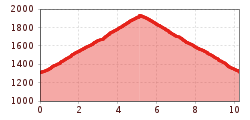
Route length: 5.3 km
Duration: 1:30 h

Medium-difficulty mountain bike tour to the Tessenberger Alm
Tour information

  • Requirement: medium
  • Length: 5.3 km
  • Duration: 1:30 h
  • Elevation uphill:630 hm
  • Elevation downhill:0 hm
Highest point1,930 m

Starting point

Heinfels-Tessenberg (1320m)

Finishing point

Tessenberger Alm (1950m)
  • Fitness level 3 / 6
  • Technique 3 / 6

Best time of year

  • January
  • February
  • March
  • April
  • May
  • June
  • July
  • August
  • September
  • October
  • November
  • December

Equipment

Basic cyclingequipmentincludes a well-fitting helmet and functionalclothingadaptedtotheweather and temperature. Essential itemsare rain, sun, and wind protection, a repair kit, a first-aid kit, a charged mobile phone, aswellassufficientfluids and provisions. Gloves and eyewearprotecthands and eyes, while lightsimprovevisibility.  A mapor a GPS deviceassistwithorientation. 
 
This informationservesas a guide and does not claimtobe exhaustive. Equipment mustalwaysbeadaptedtothe tour destination, weatherconditions, season, naturalhazards, environmental influences, and personal needs. 
Source: TVB Osttirol

Description

The starting point of this moderately difficult MTB route is the picturesque village of Tessenberg (1,320 metres). From here, the route winds its way uphill, first along a tarmac road and then along the forest path, a crisp 630 metres in altitude. The destination of the route is the Tessenberger Alm! Although it is not serviced, the sensational panoramic views of the Carnic main ridge and the Lienz and Sexten Dolomites alone make the ascent worthwhile. Bike & Hike fans can also tackle the ascent to the romantically situated "Tessenberger See"!
 

Getting here

  • Parking

    Mit dem Auto bis Tessenberg

More tours in the surrounding area

  • Adlertrail No. 138

    Difficulty:medium
    Length:3.7 kmDuration:0:20 h
  • Alban Lakata Trail No. 142

    Difficulty:medium
    Length:2.0 kmDuration:0:20 hElevation uphill:10 m
  • Peter Sagan Trail No. 141

    Difficulty:medium
    Length:5.0 kmDuration:0:30 hElevation uphill:90 m
  • Karlsbaderhütte No. 154

    Difficulty:difficult
    Length:26.2 kmDuration:4:00 hElevation uphill:1,590 m
  • Flow Family Trail Nr. 155

    Difficulty:easy
    Length:4.0 kmDuration:0:30 hElevation uphill:60 m
  • Iseltal cycle trail No. 22

    Difficulty:easy
    Length:53.0 kmDuration:3:00 hElevation uphill:300 m
Newsletter

The mountain is calling? So does our newsletter!

In our monthly newsletter we reveal the best holiday tips for Tyrol.
