
Mountainbike-Tour 111 | Fronstadler Alm

Strassen / Villgraten Mountains
Difficulty ratings: medium
Route length: 15.4 km
Duration: 2:42 h

Medium-difficulty mountain bike tour to the Fronstadler Alm
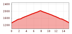
Tour information

  • Requirement: medium
  • Length: 15.4 km
  • Duration: 2:42 h
  • Elevation uphill:790 hm
  • Elevation downhill:690 hm
Highest point2,027 m

Starting point

Tessenberg/Fronstadl (1340m)

Finishing point

Fronstadlalm (2030m)
  • Fitness level 3 / 6
  • Technique 3 / 6

Best time of year

  • January
  • February
  • March
  • April
  • May
  • June
  • July
  • August
  • September
  • October
  • November
  • December

Equipment

Basic cyclingequipmentincludes a well-fitting helmet and functionalclothingadaptedtotheweather and temperature. Essential itemsare rain, sun, and wind protection, a repair kit, a first-aid kit, a charged mobile phone, aswellassufficientfluids and provisions. Gloves and eyewearprotecthands and eyes, while lightsimprovevisibility.  A mapor a GPS deviceassistwithorientation. 
 
This informationservesas a guide and does not claimtobe exhaustive. Equipment mustalwaysbeadaptedtothe tour destination, weatherconditions, season, naturalhazards, environmental influences, and personal needs. 
Source: TVB Osttirol

Description

The starting point for the "Fronstadler Alm" bike tour is the town of Fronstadl (1350 m) in the district of Strassen. From here it is initially some 400m steep uphill (tarmac). There follows a lovely scenic, meandering forest trail to the Fronstadler Alm. At kilometre 10.7 the descent offers a variant (circular course), passing "rotem Schotter" an old abandoned mine and leading at 11,9 km into the original route.


Getting here

  • Parking

    Mit dem Auto bis ins Ortszentrum von Strassen von dort mit dem Rad bis Fronstadl
    Parkplatz im Zentrum von Strassen

More tours in the surrounding area

  • Adlertrail No. 138

    Difficulty:medium
    Length:3.7 kmDuration:0:20 h
  • Alban Lakata Trail No. 142

    Difficulty:medium
    Length:2.0 kmDuration:0:20 hElevation uphill:10 m
  • Peter Sagan Trail No. 141

    Difficulty:medium
    Length:5.0 kmDuration:0:30 hElevation uphill:90 m
  • Iseltal cycle trail No. 22

    Difficulty:easy
    Length:53.0 kmDuration:3:00 hElevation uphill:300 m
  • Flow Family Trail Nr. 155

    Difficulty:easy
    Length:4.0 kmDuration:0:30 hElevation uphill:60 m
  • Karlsbaderhütte No. 154

    Difficulty:difficult
    Length:26.2 kmDuration:4:00 hElevation uphill:1,590 m
Newsletter

The mountain is calling? So does our newsletter!

In our monthly newsletter we reveal the best holiday tips for Tyrol.
