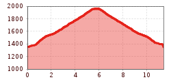
Mountainbike-Tour Gornerberg trail No. 116

Kals am Großglockner / Granatspitze Group
Difficulty ratings: medium
Route length: 11.4 km
Duration: 2:15 h

Tour information

  • Requirement: medium
  • Length: 11.4 km
  • Duration: 2:15 h
  • Elevation uphill:612 hm
  • Elevation downhill:613 hm
Highest point1,960 m

Starting point

Kals am Großglockner-Großdorf (1360m)

Finishing point

Gornalm (1930m)
  • Fitness level 3 / 6
  • Technique 4 / 6

Best time of year

  • January
  • February
  • March
  • April
  • May
  • June
  • July
  • August
  • September
  • October
  • November
  • December

Trail condition

graveled road

Equipment

Basic cyclingequipmentincludes a well-fitting helmet and functionalclothingadaptedtotheweather and temperature. Essential itemsare rain, sun, and wind protection, a repair kit, a first-aid kit, a charged mobile phone, aswellassufficientfluids and provisions. Gloves and eyewearprotecthands and eyes, while lightsimprovevisibility.  A mapor a GPS deviceassistwithorientation. 
 
This informationservesas a guide and does not claimtobe exhaustive. Equipment mustalwaysbeadaptedtothe tour destination, weatherconditions, season, naturalhazards, environmental influences, and personal needs. 
Source: TVB Osttirol

Description

From parking area cable car station GG-Resort in Kals continue along this moderatly difficult MTB-Route to Gasthof Temblerhof, further on to the top of the t-bar lift Temblerlift. Trun left uphill on the forest trail. The finish is after about 5,6 km at the middle station of the cable car station GG-Resort in Kals. From there you can go futher up to Kals-Matreier-Törl and Adlerlounge (2.404m) or go back down along the Gronerwald Trail Kals (difficult part) to the starting point.
 

Nearby huts and mountain restaurants

  • Temblerhof

    Opening hours:Today closed
    Place:Kals am Großglockner
    :Restaurant, Alpine pasture / hut / mountain restaurant
Getting here

  • Arrival by public transport

    Kals a.G. Großdorf

  • Parking

    Parkplatz Großdorf

More tours in the surrounding area

  • Adlertrail No. 138

    Difficulty:medium
    Length:3.7 kmDuration:0:20 h
  • Alban Lakata Trail No. 142

    Difficulty:medium
    Length:2.0 kmDuration:0:20 hElevation uphill:10 m
  • Flow Family Trail Nr. 155

    Difficulty:easy
    Length:4.0 kmDuration:0:30 hElevation uphill:60 m
  • Karlsbaderhütte No. 154

    Difficulty:difficult
    Length:26.2 kmDuration:4:00 hElevation uphill:1,590 m
  • Peter Sagan Trail No. 141

    Difficulty:medium
    Length:5.0 kmDuration:0:30 hElevation uphill:90 m
  • Iseltal cycle trail No. 22

    Difficulty:easy
    Length:53.0 kmDuration:3:00 hElevation uphill:300 m
Newsletter

The mountain is calling? So does our newsletter!

In our monthly newsletter we reveal the best holiday tips for Tyrol.