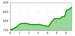
Open interactive mapOpen this POI on the interactive mapElevation profiledownloadGravelbike Tour - Benni Raich.gpx
Ausblick vom Parkplatz Bichl © Bernhard Aßmair Ski tour to the ski hut CompedalLength:2.1 kmDuration:1:30 hElevation uphill:390 mGo to skitourGo to skitour: Ski tour to the ski hut Compedal
BreitegggernLength:2.7 kmDuration:2:15 hElevation uphill:810 mGo to skitourGo to skitour: Breitegggern
Muttereralm ski touring trackLength:3.0 kmDuration:2:00 hElevation uphill:581 mGo to skitourGo to skitour: Muttereralm ski touring track
Skitour Golzentipp Panorama © German Adventurer Skitour Golzentipp über GrippLength:3.6 kmDuration:2:45 hElevation uphill:860 mGo to skitourGo to skitour: Skitour Golzentipp über Gripp
pistentour-damenabfahrt1.jpg © Joe Mann Axamer Lizum piste ski tour ladies' descentLength:3.6 kmDuration:1:45 hElevation uphill:780 mGo to skitourGo to skitour: Axamer Lizum piste ski tour ladies' descent
Hermann v. Barth Hütte © Lechtal Tourismus Elbigenalp - Hermann v. Barth HütteDifficulty:mediumLength:6.7 kmDuration:3:50 hElevation uphill:1,062 mSee trailSee trail: Elbigenalp - Hermann v. Barth Hütte
Birgitzer Alm - Birgitzköpflhaus Axamer LizumLength:6.3 kmDuration:2:00 hElevation uphill:620 mGo to skitourGo to skitour: Birgitzer Alm - Birgitzköpflhaus Axamer Lizum
Sattelberg © Tourismusverband Wipptal Sattelberg (2,115 m)Length:5.4 kmDuration:2:30 hElevation uphill:850 mGo to skitourGo to skitour: Sattelberg (2,115 m)
Lermoos - Panorma walk to EhrwaldDifficulty:easyLength:2.8 kmDuration:0:56 hElevation uphill:87 mSee trailSee trail: Lermoos - Panorma walk to Ehrwald
On-piste ski tour PatscherkofelLength:3.8 kmDuration:2:00 hElevation uphill:952 mGo to skitourGo to skitour: On-piste ski tour Patscherkofel
Rundwanderung um den PlanseeDifficulty:mediumLength:14.6 kmDuration:3:30 hElevation uphill:85 mSee trailSee trail: Rundwanderung um den Plansee
Füssener Hütte © Rene Paulweber Through the Tannheim mountains | 4-day tourDifficulty:mediumLength:35.0 kmDuration:15:00 hElevation uphill:2,200 mSee trailSee trail: Through the Tannheim mountains | 4-day tour
Putzen-Alm © TVB St. Anton am Arlberg Patrick Bätz St. Anton - PutzenalpeDifficulty:mediumLength:10.8 kmDuration:4:00 hElevation uphill:605 mSee trailSee trail: St. Anton - Putzenalpe
Komperdell Tour © © Serfaus-Fiss-Ladis Marketing GmbH Komperdell Tour 761Opening hours:openDifficulty:mediumLength:17.4 kmDuration:1:30 hElevation uphill:650 mGo to biketourGo to biketour: Komperdell Tour 761
High and sacred – Stage 01 from Lavant to St. KorbinianMore InformationMore Information: High and sacred – Stage 01 from Lavant to St. Korbinian
hochundheilig1-etappe3-obertilliach-c-peter-maier.jpg © Peter Maier High and sacred – Stage 03 from Maria Luggau to St. OswaldDifficulty:mediumLength:25.8 kmDuration:7:00 hElevation uphill:1,206 mSee trailSee trail: High and sacred – Stage 03 from Maria Luggau to St. Oswald
hochundheilig-etappe9-kalsamgrossglockner-c-peter-maier.jpg © Peter Maier High and sacred – Stage 09 from Kals to HeiligenblutMore InformationMore Information: High and sacred – Stage 09 from Kals to Heiligenblut
hochundheilig-etappe4-hollbruck-c-peter-maier.jpg © Peter Maier High and sacred – Stage 04 from St. Oswald to InnichenMore InformationMore Information: High and sacred – Stage 04 from St. Oswald to Innichen
Herrlicher Ausblick © Lechtal Tourismus PanoramawegDifficulty:mediumLength:6.6 kmDuration:3:00 hElevation uphill:470 mSee trailSee trail: Panoramaweg
Adler Trail bei der Adler Lounge © bikeboard/Roland Kachelhauser Adlertrail No. 138Difficulty:mediumLength:3.7 kmDuration:0:20 hGo to biketourGo to biketour: Adlertrail No. 138
GenießerRundWeg am Ahorn © Christian Lorenz Circular & themed hike: "GenießerRundWeg" at Mount AhornDifficulty:easyLength:2.0 kmDuration:0:45 hElevation uphill:70 mSee trailSee trail: Circular & themed hike: "GenießerRundWeg" at Mount Ahorn
High and sacred – Section 02 from St. Korbinian to Maria LuggauMore InformationMore Information: High and sacred – Section 02 from St. Korbinian to Maria Luggau
High and sacred – Stage 05 from Innichen to KalksteinMore InformationMore Information: High and sacred – Stage 05 from Innichen to Kalkstein
High and sacred – Stage 07 from St. Jakob im Defereggental to ObermauernMore InformationMore Information: High and sacred – Stage 07 from St. Jakob im Defereggental to Obermauern
Give feedback for a chance to win a special holiday experience!Click here for the surveyClick here for the survey