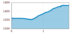
Open interactive mapOpen this POI on the interactive mapElevation profiledownloadBoden zum Angerleboden.gpx
DescriptionFrom Gasthof Bergheimat in Boden, we hike over the bridge over the Fundaisbach stream and on to the Angerlebach stream, which we follow upstream to Angerleboden.
Hike from Boden to Hanauer HutDifficulty:mediumLength:10.0 kmDuration:3:30 hElevation uphill:595 mSee trailSee trail: Hike from Boden to Hanauer Hut
large-Weg-der-Sinne-Pfafflar-5.jpg © Raimund Krabacher Hölltal - Trail of the Senses - Bschlaber HöhenwegDifficulty:mediumLength:7.4 kmDuration:2:45 hElevation uphill:295 mSee trailSee trail: Hölltal - Trail of the Senses - Bschlaber Höhenweg
Herrlicher Ausblick © Lechtal Tourismus PanoramawegDifficulty:mediumLength:6.6 kmDuration:3:00 hElevation uphill:470 mSee trailSee trail: Panoramaweg
Hermann v. Barth Hütte © Lechtal Tourismus Elbigenalp - Hermann v. Barth HütteDifficulty:mediumLength:6.7 kmDuration:3:50 hElevation uphill:1,062 mSee trailSee trail: Elbigenalp - Hermann v. Barth Hütte
Kapelle Klimm © Lechtal Tourismus Elmen - FrauenschuhrundeOpening hours:closedDifficulty:easyLength:13.2 kmDuration:3:25 hElevation uphill:73 mSee trailSee trail: Elmen - Frauenschuhrunde
Kaiserjochhaus © Lechtal Tourismus Lechtaler Höhenweg: 3. Etappe Kasierjochhaus-Ansbacher HütteDifficulty:difficultLength:7.8 kmDuration:4:45 hElevation uphill:844 mSee trailSee trail: Lechtaler Höhenweg: 3. Etappe Kasierjochhaus-Ansbacher Hütte
Lech bei Forchach. © Lechtal Tourismus Stanzach - Over the suspension bridgeDifficulty:easyLength:12.8 kmDuration:3:15 hElevation uphill:42 mSee trailSee trail: Stanzach - Over the suspension bridge
Stuttgarter HütteDifficulty:mediumLength:12.3 kmDuration:5:30 hElevation uphill:1,124 mSee trailSee trail: Stuttgarter Hütte
Blick nach Vorderhornbach © Lechtal Tourismus Stanzach - Baichlstein - high trail to VorderhornbachDifficulty:mediumLength:10.0 kmDuration:3:10 hElevation uphill:271 mSee trailSee trail: Stanzach - Baichlstein - high trail to Vorderhornbach
Kaufbeurer Haus © Lechtal Tourismus Hinterhornbach - Kaufbeurer HausDifficulty:mediumLength:3.4 kmElevation uphill:923 mSee trailSee trail: Hinterhornbach - Kaufbeurer Haus
Bach - Memminger HütteDifficulty:mediumLength:13.6 kmDuration:5:45 hElevation uphill:1,229 mSee trailSee trail: Bach - Memminger Hütte
Kaiserjochhaus © Lechtal Tourismus Hike from Kaisers to KaiserjochhausDifficulty:mediumLength:6.9 kmElevation uphill:823 mSee trailSee trail: Hike from Kaisers to Kaiserjochhaus
Holzgau suspension bridge © Lechtal Tourismus Holzgau - Suspension bridge circuitDifficulty:easyLength:4.9 kmDuration:1:30 hElevation uphill:152 mSee trailSee trail: Holzgau - Suspension bridge circuit
Leutkircher-Hütte © Lechtal Tourismus Lechtaler Höhenweg 1st stage: Stuttgarter Hütte-Leutkircher HütteDifficulty:difficultLength:6.6 kmDuration:3:15 hElevation uphill:469 mSee trailSee trail: Lechtaler Höhenweg 1st stage: Stuttgarter Hütte-Leutkircher Hütte
Bergwandern © Lechtal Tourismus Lechtaler Höhenweg: 2nd stage Leutkircher Hütte-KaiserjochhausDifficulty:difficultLength:4.4 kmDuration:2:15 hElevation uphill:312 mSee trailSee trail: Lechtaler Höhenweg: 2nd stage Leutkircher Hütte-Kaiserjochhaus
Kaisers/Boden - Leutkircher HütteDifficulty:mediumLength:8.4 kmElevation uphill:935 mSee trailSee trail: Kaisers/Boden - Leutkircher Hütte
Elbigenalp Gibler AlmDifficulty:easyLength:1.4 kmElevation uphill:153 mSee trailSee trail: Elbigenalp Gibler Alm
Lechtal, Lechtaler Höhenweg, Steinsee_Tirol Werbung_Schels Sebastian_No location given (4) © Tirol Werbung | Sebastian Schels Lechtaler HöhenwegDifficulty:difficultLength:84.5 kmDuration:11 daysElevation uphill:6,773 mSee trailSee trail: Lechtaler Höhenweg
Give feedback for a chance to win a special holiday experience!Click here for the surveyClick here for the survey