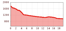
The sixth stage of the Karwendel Höhenweg trail is the descent from the Hallerangerhaus hut to Scharnitz via the Hinterautal valley.

Mountain path.
All current information about trail closures in the Seefeld region can be found here.
Have you discovered a spot that needs maintenance or repair? Fill out the 'Report a Hazard' form and let us know where work is needed in the region.
Good footwear, functional clothing, a hiking backpack, water, provisions, alpine experience, and surefootedness are necessary for this tour!
Additionally, a hiking map or GPS, a first aid kit, sun protection, trekking poles, and an emergency blanket are recommended.
After leaving the Hallerangerhaus, you follow trail 224 heading west, forming the sixth stage of the Karwendel High Trail. (Detour to Sunntigerspitze mountain: follow the sparsely marked trail leading north from the Hallerangeralm.) You pass the Kohleralm pasture hut and soon come to the Lafatscher Niederleger hut before making a somewhat more steep descent on the road down into the Hinterautal valley. You can reach the Kastenalm mountain hut by taking a brief detour at the marked junction in the road. From here, you keep heading along the road out of the valley and pass the source of the Isar river on the way. This is followed by a gentle ascent to the panoramic Gleirschhöhe (1069 m) and a leisurely descent that takes you past the Wiesenhof Lodge. You then come to the Isarbrücke bridge and subsequently complete the route in Scharnitz. After a short rest, you can pick up your well-deserved goodybag at the nature park information center with a full stamp pass.
Summits along the stage:
If you still have time and stamina, you can take the following peaks on this stage by making a detour:
• Sunntigerspitze (2321 m); Ascent: +3.5 h (red mountain trail)
Since the Karwendel Höhenweg is not a circular route, the starting and ending points do not match. Therefore, it is ideal to use public transportation for arrival and departure. From the endpoint at the Nature Park Information Center in Scharnitz, it’s just a 10-minute walk to the Scharnitz train station.