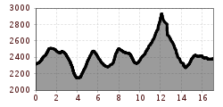
Mountain hikes Tuxer Jochhaus - Geraer Hütte - Alpeiner Scharte - Olperer Hütte

Tux/Hintertux im Zillertal / Tuxer Alpen
Difficulty ratings: difficult
Route length: 17.0 km
Duration: 9:30 h

A worthwhile high mountain tour with history!

Tour information

  • Requirement: difficult
  • Length: 17.0 km
  • Duration: 9:30 h
  • Elevation uphill:1,660 hm
  • Elevation downhill:1,600 hm
Highest point2,957 m

Starting point

Tuxer Jochhaus

Finishing point

Olperer Hütte

Best time of year

  • January
  • February
  • March
  • April
  • May
  • June
  • July
  • August
  • September
  • October
  • November
  • December

Trail condition

Teils steiler Bergweg; Alpeiner Scharte: Trittsicherheit und Schwindelfreiheit erforderlich! Nur für Geübte!
Source: Zillertal

Description

From the Tuxerjochhaus, the AV trail no. 527 leads over the Frauenwand and the Kasererscharte, passing the "Steinernes Lamm", to the Geraer Hütte (section of trail no. 525 to Steinernes Lamm) . From the Geraer Hütte, path No. 502 climbs steeply over scree slopes, past the ruins of the World War II molybdenum mine, to the Alpeiner Scharte 2,957m. 
View of the opposite Hochfeiler 3,502 m and the Untere Schrammachkar, to which the steep descent over scree requires surefootedness of the mountaineer!
At the small lakes of the Untere Schrammachkar, trail no. 502 joins AV trail no. 526 in the direction of the Olperer Hütte.

More tours in the surrounding area

Newsletter

The mountain is calling? So does our newsletter!

In our monthly newsletter we reveal the best holiday tips for Tyrol.