River Trail – Mayrhofen

Mayrhofen, Zillertal / Tuxer Alpen
Route length: 7.6 km
Duration: 0:45 h

River Trail – Mayrhofen

Tour information

  • Length: 7.6 km
  • Duration: 0:45 h
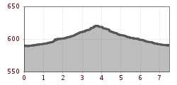
  • Elevation uphill:30 hm
  • Elevation downhill:30 hm
Highest point621 m

Starting point

Hippach-Dorf, 6283 Hippach

Finishing point

Hippach-Dorf, 6283 Hippach
Source: Zillertal

Description

From the Ziller bridge in Hippach, run along the western bank past the Auenland Sidan playground and the Burgschrofen chapel to the Zillertal Inn. Change to the other side of the river and run back down the valley.
 

More tours in the surrounding area

Newsletter

The mountain is calling? So does our newsletter!

In our monthly newsletter we reveal the best holiday tips for Tyrol.