
Opening hours:closed
Difficulty:easy
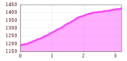
Length:5.0 kmDuration:1:45 h
Wiesenweg nach Fiss
From the village centre (L006), head south-west uphill towards the hamlet of “Razil” and continue straight on towards Fiss. Keep to the right of the ski slope to the
“Weiberkessl” ski hut and, just above it, cross the slope to the left towards Bertas Indianerland. Then continue on level ground alongside the cross-country trails to Fiss.


