Hikes in Oetz
Map

Show
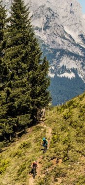
on mapMining Trail & Wetterkreuzkogel (2,592 metres), Hochoetz
on mapMining Trail & Wetterkreuzkogel (2,592 metres), Hochoetz
Themed hikes
Starting point: Top station of Acherkogelbahn cable car, Hochoetz
Length: 11km
Elevation uphill: 890m
Total hiking time: 6h
Difficulty rating: intermediate (red mountain trails)

Show
on mapOetz - Piburger See
on mapOetz - Piburger See
Mountain hikes
Starting point: Car park, Oetz
Length: 8km
Elevation uphill: 362m
Total hiking time: 3h
Difficulty rating: intermediate (red mountain trails)

Show
on mapPiburgersee Lake
on mapPiburgersee Lake
Mountain hikes
Starting point: Car park in Piburg
Length: 2km
Elevation uphill: 110m
Total hiking time: 1h
Difficulty rating: easy (hiking trails)

Show
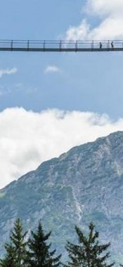
on mapThree-Day Trek: Hochoetz - Kühtai - Finstertaler Scharte - Umhausen
on mapThree-Day Trek: Hochoetz - Kühtai - Finstertaler Scharte - Umhausen
Multi-day hikes
Starting point: Oetz, Acherkogelbahn gondola top terminal (2,020m)
Length: 32km
Elevation uphill: 1,315m
Duration: 3 day(s)
Difficulty rating: intermediate (red mountain trails)
Oetz: Hikes in the region

Sölden
Walkers who complete the 640 vertical metres from Sölden to Gampe Thaya…

Sölden
Hikers wishing to enoy the fine food and breathtaking views at the Ice Q…
 in the Ötztal Alps, © Similaunhütte/Markus Pirpamer")
Vent
This walk takes fit hikers to a border region between North Tirol (Austria)…