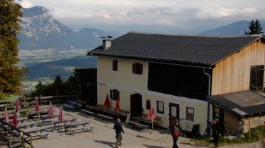
The area above Westendorf, between the Nachtsöllberg mountain and the southern peaks of the Kitzbühel Alps, walkers and hikers will find a large network of paths and trails. This route begins at the top of the Alpenrosenbahn cable car and leads up to the top of the Brechhorn, at over 2,000 metres above sea level. Most of the trail is easy, with just the final section near the summit posing more of a challenge and requiring hikers to be sure-footed. Half-way along the hike you will find the Brechhornhaus, a large mountain hut serving food and drink. Here, high above the treeline, the views are spectacular.

Summit Hike
Starting point
Top of Alpenrosenbahn cable car (1,765 metres) / Westendorf
Hike to
Brechhorn (2,032 metres)
Finishing point
Top of Alpenrosenbahn cable car (1,765 metres) / Westendorf
Mountain chain
Kitzbühel Alps
Length
12.5 km
Total hiking time
4 h 45 min
Features
- Wheelchair-accessible Hiking Route
- Circular hike
Difficulty rating
intermediate (red mountain trails)
Altitude
Elevation uphill 635m
Vertical metres downhill 635m
Fitness level
Technique
Best time of year
* These are approximate values and recommendations. Please take your personal fitness level, technical ability and the current weather conditions into account. Tirol Werbung cannot guarantee that the information provided is correct and accepts no liability.
Public transport
- Accessible using public transport
Bus route 4051, get off at stop Westendorf Sennerei
Parking
Top of Alpenrosenbahn cable car
Places serving food and drink
- Berggasthof Brechhornhaus
- Bergrestaurant Talkaser
Downloads
Trail description
This hike begins at the top of the Alpenrosenbahn cabel car (Talkaser), on the southern side of the Nachtsöllberg mountain. Walk along the road in a southern direction. At the Höhningscharte, turn left towards the Brechhornhaus and Kreuzjöchl-Speicherteich (trail 81). At a fork in the path, around half a kilometre after passing the Einködlscharte, stay left and continue to the Speicherteich (reservoir). A little further down you will reach the Brechhornhaus (1,660 metres), where you can stop for a rest – either now or on the way back. Continue along the path towards the Kreuzjoch (1,619 metres) and Schledererscharte. It is here that the steep final ascent to the Brechhorn begins, first through forest up onto the Schledererkopf (1,802 metres) and later through open terrain – with a few flatter sections – to the eastern ridge of the Brechhorn mountain (2,032 metres), where things get steeper again. Hikers must be sure-footed for this final section.
After enjoying wondferful views of the Kitzbühel Alps and the Hohe Tauern Mountains, return along the way you came. At the turning to the Feldbergalm, head west and descend to the Brandeggalm. There, turn sharp right and continue on a wide trail to the Schledernalm. After a further 400 metres take a narrower hiking trail right to the Kreuzjoch and Brechhornhaus. You will reach the hut just a few minutes later. After a drink and a snack, all that remains is to return back to the starting point at the top of the Alpenrosenbahn cable car.


