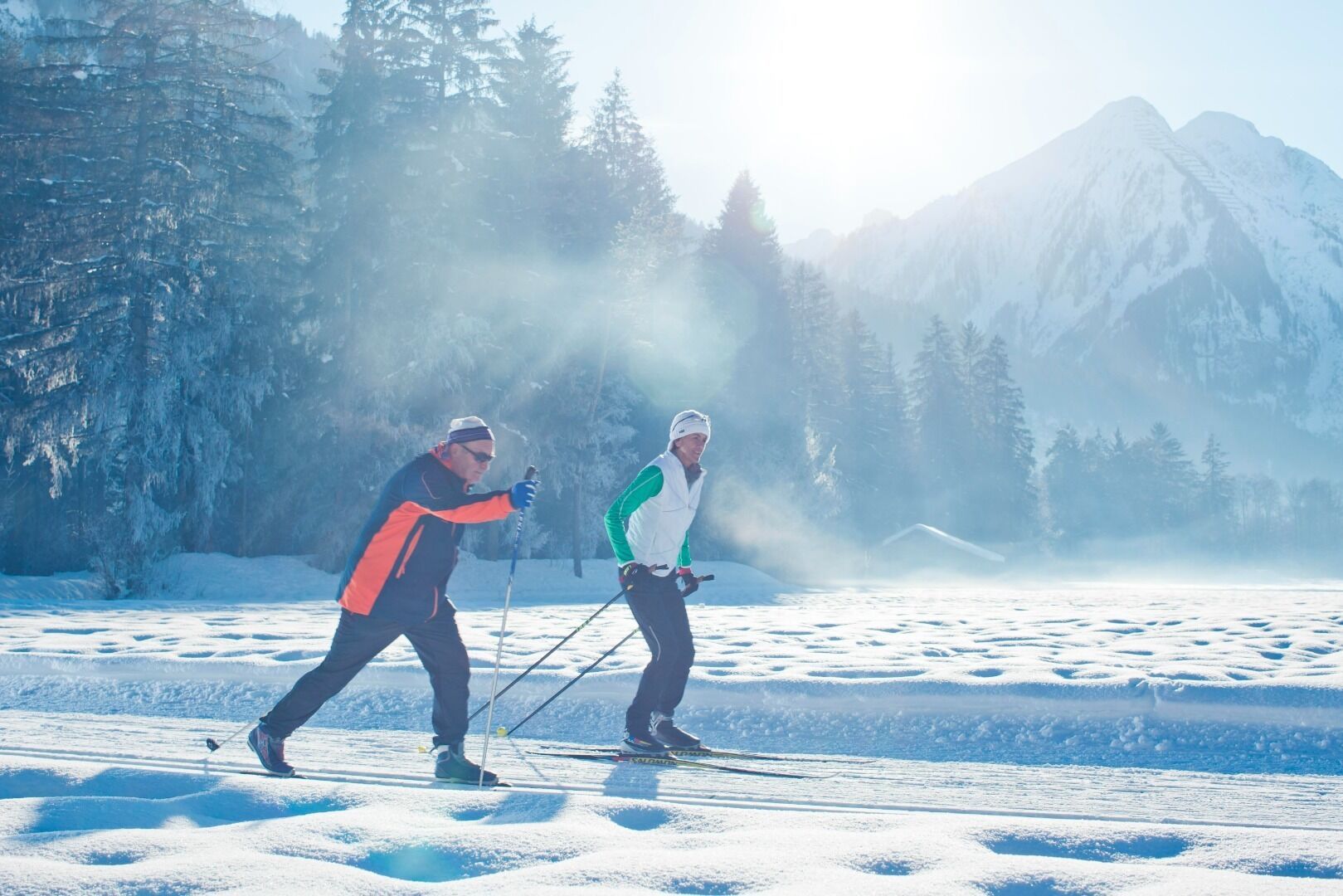
The Falkenkopf-Körbersee loop is perfect for sporty, ambitious cross-country skiers. A dream view and the Körbersee reward the effort in any case.
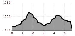
Open interactive mapOpen this POI on the interactive mapElevation profileFalkenkopf - Körbersee Runde.gpx
©-TVB-Tiroler-Oberland-Kaunertal-Die-West-Barrierefrei-Langlaufen-1 (3).jpg © Die West GmbH Adaptive cross country skiing circuit Anger at Kaunertal ValleyOpening hours:closedDifficulty:easyLength:1.0 kmElevation uphill:5 m:Style: Skating, ClassicGo to Cross-country skiing trailGo to Cross-country skiing trail: Adaptive cross country skiing circuit Anger at Kaunertal Valley
Loipe Kurzer GrundOpening hours:closedDifficulty:mediumLength:6.7 kmElevation uphill:149 m:Style: Skating, ClassicGo to Cross-country skiing trailGo to Cross-country skiing trail: Loipe Kurzer Grund
Langlaufzentrum Pertisau - Blick ins Karwendel © Achensee Tourismus Pertisau village circuitOpening hours:closedDifficulty:easyLength:3.5 kmDuration:1:00 hElevation uphill:68 m:Style: Skating, ClassicGo to Cross-country skiing trailGo to Cross-country skiing trail: Pertisau village circuit
auf der Hundeloipe in Pertisau - klassisch und skating gespurt © Achensee Tourismus Pertisau dog-friendly cross-country skiing trailOpening hours:closedDifficulty:easyLength:2.0 kmDuration:0:30 hElevation uphill:15 m:Style: Skating, ClassicGo to Cross-country skiing trailGo to Cross-country skiing trail: Pertisau dog-friendly cross-country skiing trail
Langlaufen in Maurach - einige der Loipen sind in Seenähe gespurt © Achensee Tourismus M5 - Panorama trailOpening hours:closedDifficulty:mediumLength:3.5 kmDuration:1:00 hElevation uphill:85 m:Style: Skating, ClassicGo to Cross-country skiing trailGo to Cross-country skiing trail: M5 - Panorama trail
Pertisau – Blick ins Falzthurntal und auf die frisch gespurte Loipe Falzthurn–Gramai. © Achensee Tourismus P3 - Falzthurn-Gramai trailOpening hours:closedDifficulty:mediumLength:14.0 kmDuration:2:30 hElevation uphill:285 m:Style: Skating, ClassicGo to Cross-country skiing trailGo to Cross-country skiing trail: P3 - Falzthurn-Gramai trail
Loipeneinstieg - Langlaufzentrum in Pertisau © Achensee Tourismus P4 - Pletzach-Gern trailOpening hours:closedDifficulty:mediumLength:10.0 kmDuration:2:00 hElevation uphill:228 m:Style: Skating, ClassicGo to Cross-country skiing trailGo to Cross-country skiing trail: P4 - Pletzach-Gern trail
Langlaufloipe B1 in Mösern © Region Seefeld B1 - MösernOpening hours:closedDifficulty:mediumLength:5.5 kmElevation uphill:110 m:Style: Skating, ClassicGo to Cross-country skiing trailGo to Cross-country skiing trail: B1 - Mösern
Snow-covered ski run KössenOpening hours:closedDifficulty:easyLength:2.1 kmDuration:0:15 hElevation uphill:40 m:Style: Skating, ClassicGo to Cross-country skiing trailGo to Cross-country skiing trail: Snow-covered ski run Kössen
Cross country ski trail Schmirn KasernOpening hours:closedDifficulty:easyLength:4.0 kmDuration:0:56 hElevation uphill:38 m:Style: ClassicGo to Cross-country skiing trailGo to Cross-country skiing trail: Cross country ski trail Schmirn Kasern
Loipe Maurach - dahinter der Achensee und das Freizeitzentrum Atoll Achensee © Achensee Tourismus Adaptive cross-country skiing: accessible trail in Maurach am AchenseeOpening hours:closedDifficulty:easyLength:4.0 kmDuration:1:00 hElevation uphill:21 m:Style: Skating, ClassicGo to Cross-country skiing trailGo to Cross-country skiing trail: Adaptive cross-country skiing: accessible trail in Maurach am Achensee
Langlaufen Hopfgarten Penningberg 2022 @Magdalena Laiminger (27).jpg © Magdalena Laiminger Cross-country ski trail RoggenbodenOpening hours:closedDifficulty:easyLength:2.2 kmElevation uphill:10 m:Style: Skating, ClassicGo to Cross-country skiing trailGo to Cross-country skiing trail: Cross-country ski trail Roggenboden
Tiroler Zugspitz Arena LoipeOpening hours:closedDifficulty:mediumLength:39.2 kmDuration:8:00 hElevation uphill:359 m:Style: Skating, ClassicGo to Cross-country skiing trailGo to Cross-country skiing trail: Tiroler Zugspitz Arena Loipe
Schmirn Toldern circular trailOpening hours:closedDifficulty:mediumLength:6.0 kmDuration:1:30 hElevation uphill:150 m:Style: ClassicGo to Cross-country skiing trailGo to Cross-country skiing trail: Schmirn Toldern circular trail
B23 Loipe Kelmen-Namlos - NamlosOpening hours:closedDifficulty:mediumLength:3.4 kmDuration:0:50 h:Style: Skating, ClassicGo to Cross-country skiing trailGo to Cross-country skiing trail: B23 Loipe Kelmen-Namlos - Namlos
©-TVB-Tiroler-Oberland-Kaunertal-Die-West-Barrierefrei-Langlaufen-1 (11).jpg © Die West GmbH Accessible meadow circuit for Nordic skiing beginners KaunertalOpening hours:closedDifficulty:easyLength:1.0 kmElevation uphill:3 m:Style: Skating, ClassicGo to Cross-country skiing trailGo to Cross-country skiing trail: Accessible meadow circuit for Nordic skiing beginners Kaunertal
A20 Moosloipe BerwangOpening hours:closedDifficulty:easyLength:2.6 kmDuration:0:30 h:Style: Skating, ClassicGo to Cross-country skiing trailGo to Cross-country skiing trail: A20 Moosloipe Berwang
Steinach high-altitude cross-country ski trailOpening hours:closedDifficulty:mediumLength:4.0 kmDuration:2:00 hElevation uphill:230 m:Style: ClassicGo to Cross-country skiing trailGo to Cross-country skiing trail: Steinach high-altitude cross-country ski trail
A15 Moosloipe - Heiterwang am SeeOpening hours:closedDifficulty:easyLength:4.1 kmDuration:0:45 hElevation uphill:10 m:Style: Skating, ClassicGo to Cross-country skiing trailGo to Cross-country skiing trail: A15 Moosloipe - Heiterwang am See
A3 Golf Rundloipe LermoosOpening hours:closedDifficulty:easyLength:3.8 kmDuration:1:00 hElevation uphill:8 m:Style: Skating, ClassicGo to Cross-country skiing trailGo to Cross-country skiing trail: A3 Golf Rundloipe Lermoos
Cross-country ski trail Stauden GschnitzOpening hours:closedDifficulty:easyLength:2.6 kmDuration:0:45 hElevation uphill:23 m:Style: ClassicGo to Cross-country skiing trailGo to Cross-country skiing trail: Cross-country ski trail Stauden Gschnitz
Langlaufen auf der Schwalenrunde © TVB Osttirol/Berg im Bild OG Obertilliach - SchwalenrundeOpening hours:closedDifficulty:mediumLength:4.1 kmElevation uphill:21 m:Style: Skating, ClassicGo to Cross-country skiing trailGo to Cross-country skiing trail: Obertilliach - Schwalenrunde
Langlaufen_Galtuer_2024 (61).jpg © Tourismusverband Paznaun - Ischgl L.5 Galtür-Wirl TrailOpening hours:closedDifficulty:mediumLength:5.5 kmDuration:1:50 hElevation uphill:117 m:Style: Skating, ClassicGo to Cross-country skiing trailGo to Cross-country skiing trail: L.5 Galtür-Wirl Trail
Langlauf und Biathlon in St. Johann © Mirja Geh Lärchenhof TrailOpening hours:closedDifficulty:easyLength:1.7 kmElevation uphill:11 m:Style: Skating, ClassicGo to Cross-country skiing trailGo to Cross-country skiing trail: Lärchenhof Trail
Schneerosentalloipe am Angerberg © Astner Stefan Cross-country ski trail Schneerosental AngerbergOpening hours:closedDifficulty:easyLength:7.6 kmElevation uphill:30 m:Style: Skating, ClassicGo to Cross-country skiing trailGo to Cross-country skiing trail: Cross-country ski trail Schneerosental Angerberg
Give feedback for a chance to win a special holiday experience!Click here for the surveyClick here for the survey
.jpg")
.jpg")


.jpg")


.jpg")


.jpg")


