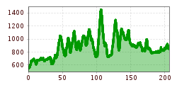
Die Naturbiken-Hauptroute verbindet das westliche Allgäu mit der Naturparkregion Reutte und nimmt Sie mit auf eine abwechslungsreiche Reise vom Allgäu bis nach Tirol
Open interactive mapOpen this POI on the interactive mapElevation profileNaturbiken Allgäu/Tirol | Hauptroute-Nord.gpx
13 Zillertal-RadwegDifficulty: easy Length: 30.5 km Duration: 2:00 h Elevation uphill: 125 m Go to biketourGo to biketour: 13 Zillertal-Radweg
Around the Lienz DolomitesDifficulty: medium Length: 112.0 km Duration: 3:30 h Elevation uphill: 1,870 m Go to biketourGo to biketour: Around the Lienz Dolomites
Tux - Höllensteinhütte-Grieralm-RundeDifficulty: medium Length: 12.5 km Duration: 2:30 h Elevation uphill: 565 m Go to biketourGo to biketour: Tux - Höllensteinhütte-Grieralm-Runde
Innradweg TirolDifficulty: easy Length: 43.9 km Duration: 3:45 h Elevation uphill: 992 m Go to biketourGo to biketour: Innradweg Tirol
Innradweg TVB Silberregion KarwendelDifficulty: easy Length: 42.9 km Duration: 3:00 h Elevation uphill: 183 m Go to biketourGo to biketour: Innradweg TVB Silberregion Karwendel
Innradweg Stage 5: Zillertal - Kufstein/Kiefersfelden (D)Difficulty: easy Length: 57.7 km Duration: 3:00 h Elevation uphill: 378 m Go to biketourGo to biketour: Innradweg Stage 5: Zillertal - Kufstein/Kiefersfelden (D)
Innradweg Innsbruck TourismusDifficulty: easy Length: 28.8 km Duration: 1:45 h Elevation uphill: 136 m Go to biketourGo to biketour: Innradweg Innsbruck Tourismus
Klammljoch - Defereggental No. 102Difficulty: medium Length: 44.0 km Duration: 5:30 h Elevation uphill: 980 m Go to biketourGo to biketour: Klammljoch - Defereggental No. 102
694 Amberger HütteOpening hours: closed Difficulty: medium Length: 23.7 km Duration: 3:00 h Elevation uphill: 960 m Go to biketourGo to biketour: 694 Amberger Hütte
Road cycling tour: Sölden - Ötztal Glacier Road up to Rettenbach GlacierDifficulty: difficult Length: 29.6 km Duration: 3:28 h Elevation uphill: 1,457 m Go to biketourGo to biketour: Road cycling tour: Sölden - Ötztal Glacier Road up to Rettenbach Glacier
SupernaturalOpening hours: open Difficulty: medium Length: 610 m Go to biketourGo to biketour: Supernatural
2031 | Sonnenrast TrailDifficulty: easy Length: 1.7 km Go to biketourGo to biketour: 2031 | Sonnenrast Trail
Bike Route Gaislach (644)Opening hours: closed Difficulty: medium Length: 18.7 km Duration: 3:04 h Elevation uphill: 835 m Go to biketourGo to biketour: Bike Route Gaislach (644)
Kitzbüheler Horn, Tour Nr. 4Length: 10.3 km Duration: 1:30 h Elevation uphill: 950 m Go to biketourGo to biketour: Kitzbüheler Horn, Tour Nr. 4
401 | Zillertaler HöhenstraßeOpening hours: open Difficulty: difficult Length: 52.6 km Duration: 7:40 h Elevation uphill: 1,890 m Go to biketourGo to biketour: 401 | Zillertaler Höhenstraße
Peter Sagan Trail No. 141Difficulty: medium Length: 5.0 km Duration: 0:30 h Elevation uphill: 90 m Go to biketourGo to biketour: Peter Sagan Trail No. 141
Högtrail 7081Opening hours: open Difficulty: easy Length: 3.8 km Go to biketourGo to biketour: Högtrail 7081
The Chainless OneDifficulty: easy Length: 7.6 km Duration: 0:10 h Go to biketourGo to biketour: The Chainless One
The Rough OneDifficulty: difficult Length: 2.0 km Duration: 0:10 h Go to biketourGo to biketour: The Rough One
Gornerwald Trail No. 139Difficulty: difficult Length: 2.3 km Duration: 0:30 h Go to biketourGo to biketour: Gornerwald Trail No. 139
"Kaunertaler Glacier road" routeDifficulty: difficult Length: 117.0 km Duration: 7:00 h Elevation uphill: 3,200 m Go to biketourGo to biketour: "Kaunertaler Glacier road" route
The First OneDifficulty: medium Length: 2.4 km Duration: 0:15 h Go to biketourGo to biketour: The First One
Innsbruck to KühtaiDifficulty: difficult Length: 110.0 km Duration: 4:30 h Elevation uphill: 1,600 m Go to biketourGo to biketour: Innsbruck to Kühtai
The Arzler Alm Trail (5007)Difficulty: medium Length: 3.8 km Duration: 0:15 h Go to biketourGo to biketour: The Arzler Alm Trail (5007)
The Hungerburg Trail (596)Difficulty: difficult Length: 550 m Duration: 0:15 h Go to biketourGo to biketour: The Hungerburg Trail (596)
Give feedback for a chance to win a special holiday experience!Click here for the surveyClick here for the survey
Andi Frank (247).jpg")

-min.jpg")


Erwin Haiden, bikeboard.at.jpg")
")


")


