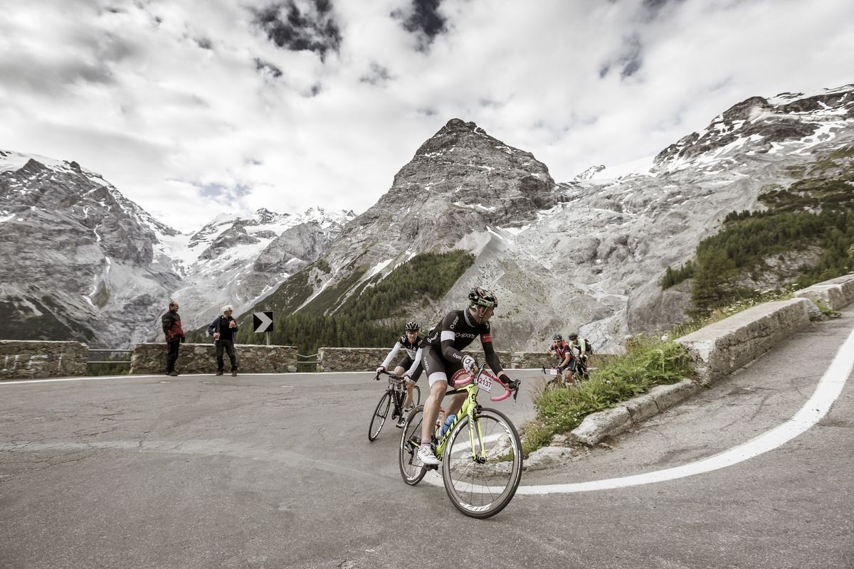
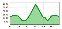
Open interactive mapOpen this POI on the interactive mapElevation profiledownloadStrecke Stelvio Vinschgau.gpx
outdooractiveImport_67919192 © TVB Stubai Stubai Radroute 19Opening hours:openDifficulty:easyLength:24.0 kmElevation uphill:364 mGo to biketourGo to biketour: Stubai Radroute 19
Komperdell Tour © © Serfaus-Fiss-Ladis Marketing GmbH Komperdell Tour 761Difficulty:mediumLength:17.4 kmDuration:1:30 hElevation uphill:650 mGo to biketourGo to biketour: Komperdell Tour 761
Singletrail Kals © Miriam Raneburger Gornerwald Trail No. 139Difficulty:difficultLength:2.3 kmDuration:0:30 hGo to biketourGo to biketour: Gornerwald Trail No. 139
Lakata Trail © bikeboard/Roland Kachelhauser Alban Lakata Trail No. 142Difficulty:mediumLength:2.0 kmDuration:0:20 hElevation uphill:10 mGo to biketourGo to biketour: Alban Lakata Trail No. 142
Frommestrail (1).jpg © (c) Serfaus-Fiss-Ladis Marketing GmbH_Raphael Pöham Frommestrail 7077Opening hours:openDifficulty:mediumLength:9.6 kmElevation uphill:12 mGo to biketourGo to biketour: Frommestrail 7077
Adlertrail © bikeboard/Roland Kachelhauser Adlertrail No. 138Difficulty:mediumLength:3.7 kmDuration:0:20 hGo to biketourGo to biketour: Adlertrail No. 138
BergkasteltrailOpening hours:openDifficulty:mediumLength:5.5 kmGo to biketourGo to biketour: Bergkasteltrail
St_Johann23©MirjaGeh_2817.jpg © Mirja Geh Flusserlebnisweg GroßacheDifficulty:easyLength:3.2 kmDuration:0:30 hElevation uphill:20 mGo to biketourGo to biketour: Flusserlebnisweg Großache
Region-Hohe-Salve-Gravel-Bike-07-2025-Fotograf-Stefan-Ringler-Web-09.jpg © Stefan Ringler SalvenaradrundeDifficulty:mediumLength:62.7 kmDuration:3:30 hElevation uphill:648 mGo to biketourGo to biketour: Salvenaradrunde
Söll_Hexenwasser_Hohe Salve_Wilder Kaiser © TVB Wilder Kaiser/Martin Raffeiner MTB Tour Söll - HochsöllDifficulty:mediumLength:5.1 kmElevation uphill:480 mGo to biketourGo to biketour: MTB Tour Söll - Hochsöll
Rennrad Bike Rad © Erwin Haiden Chiemgau circuitDifficulty:mediumLength:176.1 kmElevation uphill:723 mGo to biketourGo to biketour: Chiemgau circuit
Käsealm Straubing © Ferienregion Hohe Salve Käsealm Straubing past WindauDifficulty:mediumLength:19.8 kmDuration:2:30 hElevation uphill:270 mGo to biketourGo to biketour: Käsealm Straubing past Windau
St. Johann, Angerer Alm_Tirol Werbung_Bauer Frank_Sankt Johann in Tirol (1) © Tirol Werbung | Frank Bauer Angereralm - HarschbichlOpening hours:closedDifficulty:mediumLength:18.2 kmDuration:2:00 hElevation uphill:942 mGo to biketourGo to biketour: Angereralm - Harschbichl
Region-Hohe-Salve-Gravel-Bike-07-2025-Fotograf-Stefan-Ringler.jpg © Region Hohe Salve - Stefan Ringler Brixental cycling tour Nr. 21Difficulty:easyLength:46.7 kmDuration:3:30 hElevation uphill:450 mGo to biketourGo to biketour: Brixental cycling tour Nr. 21
26955746.jpg © TVB Wipptal 530 mountainbike SattelalmDifficulty:mediumLength:4.0 kmDuration:1:00 hElevation uphill:423 mGo to biketourGo to biketour: 530 mountainbike Sattelalm
Lienz, Peter Sagan Trail crop (1) © Tirol Werbung | Sebastian Schels Peter Sagan Trail No. 141Difficulty:mediumLength:5.0 kmDuration:0:30 hElevation uphill:90 mGo to biketourGo to biketour: Peter Sagan Trail No. 141
Leiterberg Trail © Rudi Wyhlidal Leiterberg Trail (672)Opening hours:openDifficulty:mediumLength:4.7 kmDuration:0:45 hElevation uphill:5 mGo to biketourGo to biketour: Leiterberg Trail (672)
2031 | Sonnenrast TrailDifficulty:easyLength:1.7 kmGo to biketourGo to biketour: 2031 | Sonnenrast Trail
OLLWEITE LINE © Rudi Wyhlidal Ollweite Line (6010)Opening hours:openDifficulty:mediumLength:6.8 kmDuration:1:00 hGo to biketourGo to biketour: Ollweite Line (6010)
Labalm KirchbergDifficulty:mediumLength:26.0 kmDuration:3:00 hElevation uphill:450 mGo to biketourGo to biketour: Labalm Kirchberg
Miesberg - SeerundeDifficulty:easyLength:13.2 kmDuration:1:30 hElevation uphill:130 mGo to biketourGo to biketour: Miesberg - Seerunde
Trailarea Urisee - D'Oachkätzla Line © Dominik Somweber Trailarea UriseeOpening hours:openLength:1.2 kmGo to biketourGo to biketour: Trailarea Urisee
trailcenter ötztaler höhe / wolfsrudel trail_img_80972192 © Ötztal Trailcenter Ötztaler Höhe / Wolfsrudel TrailOpening hours:openLength:1.4 kmDuration:0:24 hElevation uphill:29 mGo to biketourGo to biketour: Trailcenter Ötztaler Höhe / Wolfsrudel Trail
Kleble Alm Trail © Ötztal Kleble Alm Trail (699)Difficulty:mediumLength:2.2 kmDuration:0:30 hGo to biketourGo to biketour: Kleble Alm Trail (699)
Singletrail Leithetrail.jpg © © Serfaus-Fiss-Ladis Marketing GmbH Leithetrail 7128Opening hours:openDifficulty:easyLength:4.3 kmGo to biketourGo to biketour: Leithetrail 7128
Give feedback for a chance to win a special holiday experience!Click here for the surveyClick here for the survey


.jpg")

.jpg")


")


")


_FULL110.jpg")


