

Opening hours:Open today
Place:Westendorf
:Restaurant
Beautiful, varied , yet technically easy bike tour!
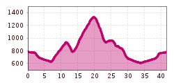
The starting point for this tour is Westendorf. Of course, you can also start from Brixen or Kirchberg - the tour is then 8 or 18 km longer.
First we head out of the village in the direction of the golf course. At the Waldhof Chapel we turn right towards Lendwirt. At the Lendwirt we keep left and after the bridge we turn right onto the "Schwaigerberg" (MTB no. 206). After the last farms, we keep to the right and now descend downhill over the Gruberberg. At the bottom of the valley, we turn left into Glantersbergstraße (MTB no. 227) which we follow to the "Ölbank" junction (no. 228). We stay on no. 227 and head downhill into the village of Kelchsau. After the church (in front of the Fuchswirt inn), we take the right fork towards Höhenbrandalm - Haag Alm (MTB no. 229). After a short while, the road turns into a gravel path. We pass the Höhenbrandalm and after a few metres we have reached the Haag Alm. From now on we head (mostly) downhill in the direction of Penningberg - Hopfgarten, always following the signposting no. 229. If you don't want to visit the village of Hopfgarten, keep to the right at the bottom of the valley (junction with the Kelchsau road) and cycle a short distance towards Kelchsau. Via a large bridge on the left we arrive in the Elsbethen settlement. Here we follow cycle path no. 21 (Brixental cycle path) and come back to the junction "Glantersberg" and "Gruberberg". We are now directly in front of a large sawmill. We keep to the right and follow the main road for a short distance until we turn right under the railway bridge into the Windautal valley or Westendorf. At the Lendwirt, we can take the familiar route back up to Westendorf, or we can keep on straight ahead in the direction of Jägerhäusl where we turn left towards Westendorf (cycle path no. 21). This way we can avoid the steep incline at Lendwirt!


