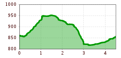
Open interactive mapOpen this POI on the interactive mapElevation profiledownloadBachpromenade Auffach.gpx
Wildschönau Niederau Auenweg Sommer © Wildschönau Tourismus Auenweg NiederauDifficulty:easyLength:1.0 kmDuration:0:30 hElevation uphill:31 mGo to winter hikeGo to winter hike: Auenweg Niederau
Kundl GorgeDifficulty:easyLength:6.5 kmDuration:3:00 hElevation uphill:10 mSee trailSee trail: Kundl Gorge
Wildschönau Auffach Schatzberg Familienwanderung.jpg © Wildschönau Tourismus Johannes Sautner Rechte Skijuwel und Wildschönau Schatzberg and Joel SpitzeDifficulty:mediumLength:7.3 kmDuration:3:00 hElevation uphill:400 mSee trailSee trail: Schatzberg and Joel Spitze
Wildschönau Niederau Markbachjoch Kapelle Winter.jpg © Wildschönau Tourismus Winterwanderung Markbachjoch - NiederauDifficulty:mediumLength:10.5 kmDuration:4:00 hElevation uphill:56 mGo to winter hikeGo to winter hike: Winterwanderung Markbachjoch - Niederau
Wildschönau Niederau Foisching © Hannes Dabernig Niederau - Foisching HutDifficulty:easyLength:6.5 kmDuration:2:15 hElevation uphill:253 mGo to winter hikeGo to winter hike: Niederau - Foisching Hut
BreitegggernLength:2.7 kmDuration:2:15 hElevation uphill:810 mGo to skitourGo to skitour: Breitegggern
Breitegg tourDifficulty:mediumLength:11.0 kmDuration:5:00 hElevation uphill:680 mSee trailSee trail: Breitegg tour
Wildschönau Oberau Achentalalm © Wildschönau Tourismus Oberau - KragenjochkreuzDifficulty:mediumLength:7.9 kmDuration:3:00 hElevation uphill:513 mSee trailSee trail: Oberau - Kragenjochkreuz
Wildschönau Wildschönauer Höhenweg © Wildschönau Tourismus H. Dabernig The Wildschönau High TrailDifficulty:mediumLength:14.8 kmDuration:6:30 hElevation uphill:760 mSee trailSee trail: The Wildschönau High Trail
Wildschönau Niederau Möslalmkogel Gipfelkreuz © Wildschönau Tourismus Möslalm circular routeDifficulty:easyLength:9.8 kmDuration:3:00 hElevation uphill:289 mSee trailSee trail: Möslalm circular route
Wildschönau Auffach Kapelle Schönanger.jpg © Wildschönau Tourismus Winter walk SchönangerDifficulty:easyLength:3.6 kmDuration:1:00 hElevation uphill:80 mGo to winter hikeGo to winter hike: Winter walk Schönanger
Wildschönau Schönanger Loipe © Wildschönau Tourismus Schönanger SlopeOpening hours:closedDifficulty:mediumLength:6.0 kmDuration:1:30 hElevation uphill:120 m:Style: ClassicGo to Cross-country skiing trailGo to Cross-country skiing trail: Schönanger Slope
Give feedback for a chance to win a special holiday experience!Click here for the surveyClick here for the survey