
Fitnesstrail

Söll /
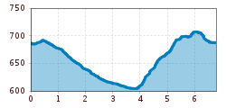
Route length: 8.0 km

Fitnesstrail

Tour information

  • Length: 8.0 km
  • Elevation uphill:100 hm
  • Elevation downhill:100 hm
Highest point710 m

Starting point

Sports ground, Söll (687 m)

Finishing point

Sports ground, Söll (687 m)
  • Fitness level 2 / 6
  • Technique 2 / 6

Best time of year

  • January
  • February
  • March
  • April
  • May
  • June
  • July
  • August
  • September
  • October
  • November
  • December

Equipment

Running shoes or trail running shoes (depending on the route), comfortable, breathable clothing, poss. lightweight rucksack with water bottle and snacks
Source: TVB Wilder Kaiser

Description

The starting point is the football field, from where you first walk past the fire station to the Gänsleit district along the road. Directly behind the Hotel Gänsleit we continue on the gravel road to the parking lot of the Ahornsee. From there, the running route leads to a wooden bridge on the left in the direction of the district of Bach. Continue straight ahead to get back onto the asphalted Gänsleitstraße in the direction of Hauning. On your left you will now see the 'Hohe Brücke' over which the B178 federal road runs. Follow the downhill gravel path under the bridge before you come across the cycle path renovated in 2023 in the district of Stockach again. At the next intersection, turn left to reach the narrow path that then runs parallel to the Weißache. Now walk along the gravel road and then cross the federal highway through an underpass in front of the Gasthof Oberstegen. The last ascent awaits you after the Gasthof Oberstegen up to the Moorsee and the Franzlhof. From here it goes over a dirt road to the Schnapflwald past the war memorial to the district of Sonnbichl. Via the road downhill you finally reach the sports field again.
 

Getting here

  • Arrival by public transport

    KaiserJet stop "Söll Kreisverkehr - Steig B" or Postbus stop "Söll Kreisverkehr"
    More information at: www.wilderkaiser.info/mobility
     

  • Parking

    Public car park East Wilder Kaiser, Söll - free of charge
     

Weather

Today

light rain showers
18°C/8°C
60%0.8l5 km/h

Sat

clear sky
21°C/6°C
0%0l0 km/h

Sun

mainly clear
23°C/8°C
70%3l0 km/h
Go to weather forecast

More tours in the surrounding area

  • Kaiserkrone - stage 3

    Difficulty:medium
    Length:9.3 kmDuration:4:30 hElevation uphill:840 m
  • 3-day hut tour Wilder Kaiser

    Difficulty:difficult
    Length:24.6 kmDuration:14:00 hElevation uphill:2,060 m
  • Tauernblick panorama circular hiking route

    Difficulty:medium
    Length:13.6 kmDuration:6:00 hElevation uphill:980 m
  • Winter walking Biedringer Platte

    Opening hours:closed
    Length:12.7 kmDuration:5:30 hElevation uphill:470 m
  • Hochalm hike

    Difficulty:medium
    Length:19.6 kmDuration:7:00 hElevation uphill:1,140 m
  • Hintere Goinger Halt summit tour

    Difficulty:difficult
    Length:9.3 kmDuration:6:30 hElevation uphill:1,090 m
  • Panoramic circuit Brandstadl–Hartkaiser

    Difficulty:easy
    Length:6.0 kmDuration:1:50 hElevation uphill:170 m
  • MTB Tour Söll - Hochsöll

    Difficulty:medium
    Length:5.1 kmElevation uphill:480 m
  • “Moor & more” Rocky Way

    Difficulty:easy
    Length:8.0 kmDuration:3:00 hElevation uphill:380 m
  • Astberg circular hiking route

    Difficulty:easy
    Length:1.5 kmDuration:0:30 hElevation uphill:80 m
  • Kaiserkrone - stage 1

    Difficulty:medium
    Length:8.0 kmDuration:4:30 hElevation uphill:1,120 m
  • Eagle Walk Stage 02: Gaudeamushütte - Kaindlhütte

    Difficulty:medium
    Length:15.1 kmDuration:6:30 hElevation uphill:888 m
  • Astberg Trail

    Length:9.7 kmElevation uphill:500 m
Newsletter

The mountain is calling? So does our newsletter!

In our monthly newsletter we reveal the best holiday tips for Tyrol.
