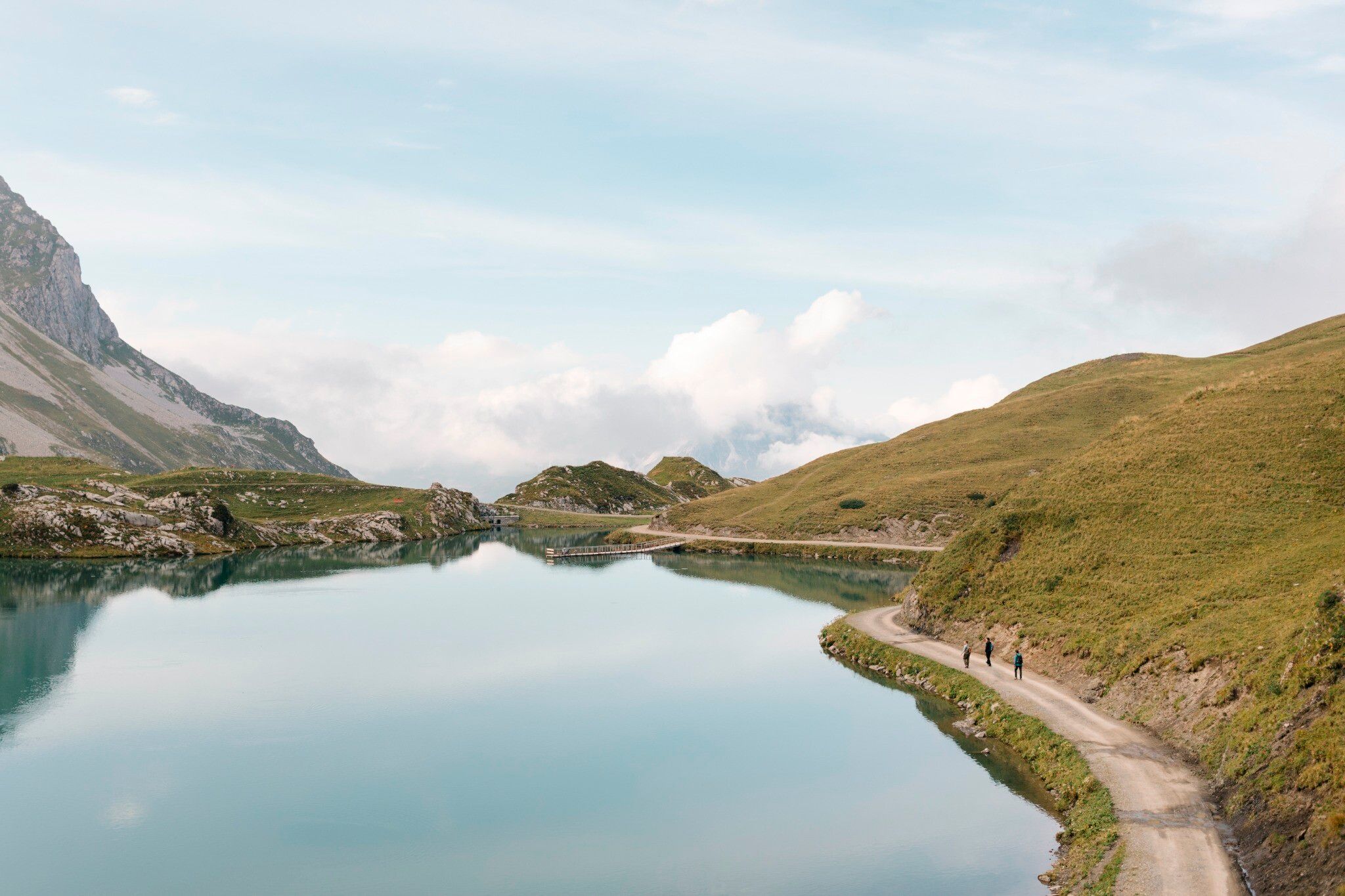
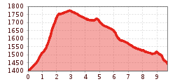
Open interactive mapOpen this POI on the interactive mapElevation profileArlberg Trail Stuben - Lech (easy alternative).gpx
Der Murmliweg in Serfaus © © Serfaus-Fiss-Ladis Marketing GmbH Marmot TrailOpening hours:closedDifficulty:easyLength:573 mDuration:0:20 hElevation uphill:12 mSee trailSee trail: Marmot Trail
Mountain hut tour: Birgitzköpfl - Muttereralm - Götzner Alm - Birgitzer AlmDifficulty:mediumLength:11.4 kmDuration:3:30 hElevation uphill:894 mSee trailSee trail: Mountain hut tour: Birgitzköpfl - Muttereralm - Götzner Alm - Birgitzer Alm
Winter- und Schneeschuhwandern (c) Mirja Geh (26).jpg © Mirja Geh At the foot of Fleischbank and TotenkirchlDifficulty:easyLength:9.3 kmDuration:3:00 hElevation uphill:250 mGo to winter hikeGo to winter hike: At the foot of Fleischbank and Totenkirchl
img_9853.jpg © @ualm.at 3-hut hikeDifficulty:mediumLength:13.2 kmDuration:6:00 hElevation uphill:1,120 mSee trailSee trail: 3-hut hike
Falkenhütte neu © Falkenhütte Karwendelmarsch 52 kmDifficulty:difficultLength:52.0 kmDuration:19:00 hElevation uphill:2,281 mSee trailSee trail: Karwendelmarsch 52 km
Abstieg in Richtung Oberstalleralm © edifilm75 Herz-Ass VillgratentalDifficulty:mediumLength:75.6 kmDuration:34:00 hElevation uphill:5,703 mSee trailSee trail: Herz-Ass Villgratental
Suspension bridge to Maria Locherboden pilgrimage churchDifficulty:mediumLength:8.5 kmDuration:3:00 hElevation uphill:370 mSee trailSee trail: Suspension bridge to Maria Locherboden pilgrimage church
St. Sigmund - Pforzheimer Hütte mountain hut (145)Difficulty:mediumLength:14.1 kmDuration:5:00 hElevation uphill:781 mSee trailSee trail: St. Sigmund - Pforzheimer Hütte mountain hut (145)
Axamer Lizum to Halsl and then on to Saile/NockspitzeDifficulty:mediumLength:9.4 kmDuration:5:00 hElevation uphill:886 mSee trailSee trail: Axamer Lizum to Halsl and then on to Saile/Nockspitze
The Zirbenweg trailDifficulty:easyLength:7.0 kmDuration:2:30 hElevation uphill:200 mSee trailSee trail: The Zirbenweg trail
wanderung-grosser-zunig-wokenmeer-c-bernhard-assmair.jpg © Bernhard Aßmair Lasörling altitude trailDifficulty:mediumLength:57.0 kmDuration:25:00 hElevation uphill:3,740 mSee trailSee trail: Lasörling altitude trail
wandern2-neuepragerhuette-c-dezordo-desiree.jpg © Desirèe De Zordo Venediger altitude trailDifficulty:difficultLength:55.5 kmDuration:27:00 hElevation uphill:3,915 mSee trailSee trail: Venediger altitude trail
Nördlinger Hütte - Wanderer kurz vor der Hütte (2).jpg © Region Seefeld, newcreatings Hike via Nördlinger Hütte to Reither SpitzeDifficulty:difficultLength:9.9 kmDuration:7:30 hElevation uphill:1,190 mSee trailSee trail: Hike via Nördlinger Hütte to Reither Spitze
Along the Goetheweg trail to thePfeishütte mountain hutDifficulty:difficultLength:5.2 kmDuration:5:00 hElevation uphill:769 mSee trailSee trail: Along the Goetheweg trail to thePfeishütte mountain hut
The sunny plateau circuitDifficulty:easyLength:38.0 kmDuration:8:00 hElevation uphill:740 mSee trailSee trail: The sunny plateau circuit
Bergdoktor-Winter Hiking TrailDifficulty:easyLength:2.1 kmDuration:0:45 hElevation uphill:40 mGo to winter hikeGo to winter hike: Bergdoktor-Winter Hiking Trail
Figerhorn - Goßglockner_TVB Osttirol_Elias Bachmann_Kals am Großglockner (1) © TVB Osttirol | Elias Bachmann FigerhornDifficulty:difficultLength:6.5 kmDuration:6:00 hElevation uphill:807 mSee trailSee trail: Figerhorn
Mountain station Spieljochbahn - Hochfügen Difficulty:mediumLength:12.2 kmDuration:4:00 hElevation uphill:270 mSee trailSee trail: Mountain station Spieljochbahn - Hochfügen
2019_best-of-zillertal_image_stummerberg_bike-and-hike_level26_web_20 (1).jpg © (c) Ferienregion Fügen-Kaltenbach im Zillertal, level26 Hamberg (2095m) from the Gasthof Almluft (Trail No. 37)Difficulty:mediumLength:9.4 kmDuration:4:45 hElevation uphill:865 mSee trailSee trail: Hamberg (2095m) from the Gasthof Almluft (Trail No. 37)
Sonnenaufgang_Kleiner_Gilfert_©FranzKupfner.jpg © (c) Ferienregion Fügen-Kaltenbach im Zillertal, Franz Kupfner Hochfügen - Kleiner Gilfert (2388m) Walk no. 27Difficulty:mediumLength:14.4 kmDuration:6:00 hElevation uphill:925 mSee trailSee trail: Hochfügen - Kleiner Gilfert (2388m) Walk no. 27
Europakreuz auf der Gr. Kinigat © A. Goller Carnic altitude trail. Stage 3: Obstansersee Hütte – PorzehütteDifficulty:mediumLength:11.3 kmDuration:6:00 hElevation uphill:650 mSee trailSee trail: Carnic altitude trail. Stage 3: Obstansersee Hütte – Porzehütte
wallfahrtskirche-maria-schnee-obermauern-nilbach-hoch-c-bernhard-assmair.jpg © Bernhard Aßmair Theme path "Virgen crossroads"Difficulty:easyLength:3.2 kmDuration:1:00 hElevation uphill:104 mSee trailSee trail: Theme path "Virgen crossroads"
Württemberger Haus 2.220m © Roman Huber Zams - Württemberger HausDifficulty:mediumLength:10.1 kmDuration:11:20 hElevation uphill:1,554 mSee trailSee trail: Zams - Württemberger Haus
Zillertal, Kaltenbach, Wedelhütte_Tirol Werbung_Bauer Frank_Kaltenbach © Tirol Werbung | Frank Bauer Mountain Hike to the WedelhütteDifficulty:mediumLength:3.0 kmDuration:3:00 hElevation uphill:490 mSee trailSee trail: Mountain Hike to the Wedelhütte
Kreuzwiese_c8e91882528c18c36b38216f9f5e6705 © Kreuzwiesenalm Foodie TrailDifficulty:easyLength:3.0 kmDuration:1:39 hElevation uphill:210 mSee trailSee trail: Foodie Trail
Give feedback for a chance to win a special holiday experience!Click here for the surveyClick here for the survey


 Mirja Geh (26).jpg")


.jpg")
")


")
Manfred Pfister.jpg")
.jpg")


