Mountain hikes Elsalmweg

Finkenberg, Zillertal / Zillertal Alps
Difficulty ratings: medium
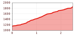
Route length: 2.5 km

On old paths to the rustic Elsalm!

Tour information

  • Requirement: medium
  • Length: 2.5 km
  • Elevation uphill:700 hm
  • Elevation downhill:0 hm
Highest point1,850 m

Starting point

Bushaltestelle Tux-Vorderlanersbach Bärdille

Finishing point

Elsalm

Best time of year

  • January
  • February
  • March
  • April
  • May
  • June
  • July
  • August
  • September
  • October
  • November
  • December

Trail condition

Bergweg
Source: Zillertal Tourismus GmbH

Description

The access is at the hairpin bend "Tuxegg" next to the dam of the Elsbach. On the challenging mountain path we climb up through the forest to the Elsalm. 
From there, further routes lead over the Tettensjoch into the valley to Tux-Lanersbach, over "Am Flach" to the Höllensteinhütte and further to Juns or Tux-Lanersbach. From the Elsalm an ALPINE ROUTE goes over the Lachtalscharte to the Gamshütte.

Weather

Today

clear sky
22°C/7°C
45%0.5l5 km/h

Thu

light rain showers
17°C/8°C
85%17.6l5 km/h

Fri

cloudy
12°C/6°C
50%0.2l5 km/h
Go to weather forecast

More tours in the surrounding area

Newsletter

The mountain is calling? So does our newsletter!

In our monthly newsletter we reveal the best holiday tips for Tyrol.