Mountain hikes Fiss over Obladis

open
Fiss / Samnaun Group
Difficulty ratings: easy
Route length: 13.0 km
Duration: 4:30 h

Fiss over Obladis

Tour information

  • Requirement: easy
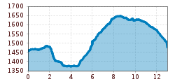
  • Length: 13.0 km
  • Duration: 4:30 h
  • Elevation uphill:556 hm
  • Elevation downhill:502 hm
Highest point1,649 m

Starting point

Latschthayaweg

Finishing point

Fiss

Features

  • Circular route
  • suitable for pushchairs
Source: Serfaus-Fiss-Ladis

Description

Walk on trail no. 3 (F008) as far as you reach the big crossing just before Wodeturm tower (L027), turn left and go up to the Kitzschrofenweg trail, then sharp left (L032), continue on this trail to Fisser Almweg trail no. 4 (F031) and via Rabuschl (F025) back to Fiss.

Nearby huts and mountain restaurants

Getting here

  • Arrival by public transport

    Fiss can be easily reached with the hiking bus line 221, which runs between Serfaus, Fiss and Ladis. Please get off at theFiss Mittelstation stop.
    If you are travelling from Ried, Prutz or Landeck, you can take the regular bus line 220.
     

Weather

Today

clear sky
26°C/10°C
5%0l5 km/h

Wed

light rain showers
27°C/14°C
60%4.8l5 km/h

Thu

clear sky
30°C/13°C
0%0l5 km/h
Go to weather forecast

More tours in the surrounding area

Newsletter

The mountain is calling? So does our newsletter!

In our monthly newsletter we reveal the best holiday tips for Tyrol.