Mountain hikes Fiss to the Fisser Joch

open
Fiss / Samnaun Group
Difficulty ratings: easy
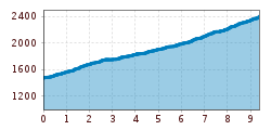
Route length: 9.4 km
Duration: 3:00 h

Fiss to the Fisser Joch

Tour information

  • Requirement: easy
  • Length: 9.4 km
  • Duration: 3:00 h
  • Elevation uphill:944 hm
  • Elevation downhill:77 hm
Highest point2,335 m

Starting point

Schönjochbahn valley station

Finishing point

Fisser Joch

Features

  • suitable for pushchairs

Trail condition

Road or forest track, partly asphalted
Source: Serfaus-Fiss-Ladis

Description

From the Schönjochbahn valley terminal (F129) follow the vehicle track (Jochweg trail) along splendid mountain meadows to the Lahnewald forest (F118). Then turn right to the Kuhalm (F121), from there either go left over the steeper cattle path (F060, a bit shorter) or right over the main trail on to the Steinegg (F061, Schönjochbahn midway station). In lots of serpentines, the trail winds its way upwards, past the huge avalanche protection basin and the Wonnealm to the Schönjochbahn mountain terminal (F087) with its restaurant BergDiamant on the Fisser Joch 2,436 m.

Nearby huts and mountain restaurants

Weather

Today

clear sky
26°C/10°C
5%0l5 km/h

Wed

light rain showers
27°C/14°C
60%4.8l5 km/h

Thu

clear sky
30°C/13°C
0%0l5 km/h
Go to weather forecast

More tours in the surrounding area

Newsletter

The mountain is calling? So does our newsletter!

In our monthly newsletter we reveal the best holiday tips for Tyrol.