
Mountain hikes Frommes via Obladis

open
Ladis / Samnaun Group
Difficulty ratings: easy
Route length: 6.6 km
Duration: 3:00 h

A scenic mountain hike via Obladis to Frommes, featuring impressive panoramic views and varied alpine scenery.
Tour information

  • Requirement: easy
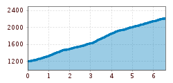
  • Length: 6.6 km
  • Duration: 3:00 h
  • Elevation uphill:1,010 hm
  • Elevation downhill:0 hm
Highest point2,218 m

Starting point

Upper village fountain

Finishing point

Frommes
  • Fitness level 2 / 6

Best time of year

  • January
  • February
  • March
  • April
  • May
  • June
  • July
  • August
  • September
  • October
  • November
  • December
Source: Serfaus-Fiss-Ladis

Description

From the upper village fountain (L007, waterwheel) go along the Spiel- und Erlebnisweg (Play and Experience Trail). At the crossing at the edge of the forest (L056), the trail leads to the left through the forest up to Obladis (L065). Go past the barn on the right, up the short trail where you see the crossing in the trail to the left into the forest which now becomes steeper. Keep left, cross the forest track and follow the ascending forest trail on the left no. 5 (L018). At a forest clearing go right up (F021) the marked trail to the Rabuschlweg trail no. 4 (F023). The trail heads in the direction of Frommes into the Schlosswald forest (F024). After two more forest trail crossings, you reach the crossing at Windles (F053). A little detour on the wide trail to the left leads to the Frommes Alp (F055). Keep a little to the right and cross a tiny brook, the trail leads to the Frommeskreuz (F071), also known as the Mattekopf.


Nearby huts and mountain restaurants

Getting here

  • Arrival by public transport

    Take the bus to Fiss. From there, take the Schönjochbahn to the mountain station, the starting point of the tour.

  • Parking

    Parking is available in Ladis. Depending on the starting point of the tour, different car parks are available. The car parks are subject to a fee.

Weather

Today

mainly clear
22°C/10°C
5%0l5 km/h

Mon

mainly clear
19°C/8°C
5%0l5 km/h

Tue

clear sky
17°C/6°C
0%0l5 km/h
Go to weather forecast

More tours in the surrounding area

  • Wild Animals Trail

    Opening hours:open
    Difficulty:easy
    Length:1.5 kmDuration:0:31 hElevation uphill:1 m
  • Panorama - Genussweg

    Opening hours:open
    Difficulty:easy
    Length:1.1 kmDuration:1:15 hElevation uphill:282 m
  • Marmot Trail

    Opening hours:open
    Difficulty:easy
    Length:573 mDuration:0:20 hElevation uphill:12 m
  • Murmeltiersteig (Marmot alpine trail)

    Opening hours:open
    Difficulty:medium
    Length:6.9 kmDuration:3:00 hElevation uphill:302 m
  • Six Senses trail

    Opening hours:open
    Difficulty:easy
    Length:6.5 kmDuration:4:00 hElevation uphill:99 m
  • Oberer Spinnsee

    Opening hours:open
    Difficulty:medium
    Length:11.2 kmDuration:5:00 hElevation uphill:427 m
  • Fiss to the Oberen Sattelkopf

    Opening hours:open
    Difficulty:medium
    Length:5.6 kmDuration:3:00 hElevation uphill:1,057 m
  • Forscherpfad

    Opening hours:open
    Difficulty:easy
    Length:3.4 kmDuration:1:30 hElevation uphill:219 m
Newsletter

The mountain is calling? So does our newsletter!

In our monthly newsletter we reveal the best holiday tips for Tyrol.
