
Opening hours:Open today
Place:Galtür
:Restaurant, Alpine pasture / hut / mountain restaurant, café
Medium difficulty hike to the "Bielerspitze" mountain
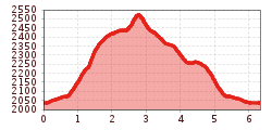
By car or by bus get to the Bielerhöhe at 2.037 m. From Berggasthof Piz Buin proceed to West to the chapel, before the route then takes a sharp right and turns off, heading up to the Bielerkopf, where there is a summit cross. The narrow path continues up to the Bielerspitze at 2.545 m, where you get a fantastic view to Silvretta Stausee, and also to the mighty Piz Buin. Return section: follow the same route back to the East and take the tracks until you get to the route heading for Vallüla. Turn off here and hike down to Passhöhe.
With the railway station in Landeck, the Paznaun is optimally connected to the Austrian train network. From Landeck-Zams station, only a short bus ride separates you from the Paznaun. Every half hour, line bus 260 runs from there through the valley. Bus stop: Bielerhöhe Silvrettasee
Buses in the Paznaun valley | Region Paznaun – Ischgl


.jpg")


Manfred Pfister.jpg")


