Mountain hikes Stage 4: Upper Valley Dream Stage

Ischgl / Silvretta
Difficulty ratings: difficult
Route length: 16.7 km
Duration: 7:30 h

Today's stage also makes your thigh muscles burn once again. Many kilometers, many altitude meters uphill and downhill are on the program. Lace up your mountain boots, pack your rucksack, check the weather and then: eyes wide open and off you go! The panorama of this high alpine landscape drives us tirelessly to Galtür, our destination for today.

Tour character

Difficult, energy-sapping stage on black mountain paths. Alpine experience, surefootedness and a head for heights are required today. The tour leads over a suspension bridge, ridges and steep, high alpine terrain. Very demanding in terms of fitness.

Tour information

  • Requirement: difficult
  • Length: 16.7 km
  • Duration: 7:30 h
  • Elevation uphill:1,352 hm
  • Elevation downhill:1,124 hm
Highest point2,472 m

Starting point

Talstation Pardatschgratbahn

Finishing point

Galtür Sport und Kulturzentrum

Features

  • Multi-day hike

Best time of year

  • January
  • February
  • March
  • April
  • May
  • June
  • July
  • August
  • September
  • October
  • November
  • December

Trail condition

Wanderweg
Source: Paznaun - Ischgl

Description

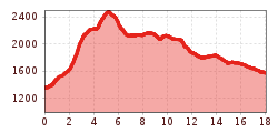
The next stage of the trail continues from the valley station of Pardatschgratbahn cable car and runs to the Kitzloch suspension bridge. After crossing Fimbabach river, you get to a footpath. Follow the signpost to Rauher Kopf. Before reaching the summit, there’s a steep, exhausting section that runs through the forest and up to Tschamatschkopf at 2,145 metres above sea level. From there, you can enjoy stunning views of the summerly Silvretta Arena ski area. Continue along the hilly trail towards the vast plateau and the Rauher Kopf at 2,478 metres above sea level. Once again, this is an excellent spot to enjoy scenic views of the entire Paznaun valley. From the summit, the marked trail runs further into the valley, along the ridge that takes you down to Außerbergli at 2,080 metres above sea level. Continue along the mountainside until you reach Innerbergli at 2,066 metres above sea level. From there, you can make a short detour to turquoise Lake Berglisee. From Innerbergli, a longer downhill section takes you to Larein Alpe mountain lodge at 1,860 metres above sea level, where you can enjoy a large variety of home-made, traditional delicacies. From there, continue downhill towards Stafali Weiher pond and the Galtür High Route.

Nearby huts and mountain restaurants

Getting here

More tours in the surrounding area

Newsletter

The mountain is calling? So does our newsletter!

In our monthly newsletter we reveal the best holiday tips for Tyrol.