Mountain hikes Hiking tour to Lucknerhütte 2.241m

Kals am Großglockner / Glocknergruppe
Difficulty ratings: medium
Route length: 5.2 km
Duration: 2:20 h

Hiking tour to Lucknerhütte 2.241m

Tour information

  • Requirement: medium
  • Length: 5.2 km
  • Duration: 2:20 h
  • Elevation uphill:320 hm
  • Elevation downhill:319 hm
Highest point2,241 m

Starting point

Lucknerhaus

Finishing point

Lucknerhütte
  • Fitness level 3 / 6
  • Technique 2 / 6

Features

  • Suitable for families
Source: TVB Osttirol

Description

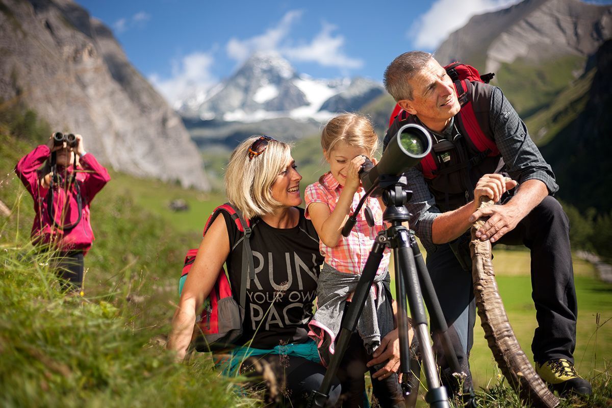
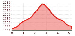
Easy walking tour, suitable for all ages, from parkingarea Glocknerwinkel along the varied Ködnitztal-valley. Follow AV path number 702B past romantic alps and a original chapel, the Großglockner constantly in your eyes. 
With a little luck you will see the "Big Five" of the Nationalpark Hohe Tauern ( bearded vulture, golden eagle, ibex, marmot, chamois)

Nearby huts and mountain restaurants

More tours in the surrounding area

  • Hike to the Venedigerhaus Innergschlöß

    Difficulty:easy
    Length:8.6 kmDuration:2:30 hElevation uphill:184 m
  • Lucknerhaus - Stüdlhütte

    Difficulty:medium
    Length:9.3 kmDuration:5:30 hElevation uphill:862 m
  • Badener Hütte

    Difficulty:difficult
    Length:23.2 kmDuration:11:30 hElevation uphill:1,754 m
  • Hike to Kalser Tauernhaus

    Difficulty:medium
    Length:12.2 kmDuration:4:00 hElevation uphill:244 m
  • Hiking tour to Neue Sajathütte 2.600m

    Difficulty:medium
    Length:10.3 kmDuration:6:50 hElevation uphill:1,086 m
  • Hiking tour to Zupalsee Hütte 2.350m

    Difficulty:medium
    Length:14.9 kmDuration:8:40 hElevation uphill:1,261 m
  • Hike to Neuen Reichenberger Hütte

    Difficulty:medium
    Length:18.2 kmDuration:9:00 hElevation uphill:1,252 m
  • Hiking tour to Lasörlinghütte 2.350m

    Difficulty:medium
    Length:14.6 kmDuration:7:10 hElevation uphill:1,080 m
  • Lasörling altitude trail

    Difficulty:medium
    Length:57.0 kmDuration:25:00 hElevation uphill:3,740 m
  • Venediger altitude trail

    Difficulty:difficult
    Length:55.5 kmDuration:27:00 hElevation uphill:3,915 m
  • Figerhorn

    Difficulty:difficult
    Length:6.5 kmDuration:6:00 hElevation uphill:807 m
  • Muhs panorama trail

    Difficulty:medium
    Length:15.2 kmDuration:6:00 hElevation uphill:1,090 m
  • Rollitour with Swiss Trac

    Difficulty:easy
    Length:3.2 kmDuration:1:30 hElevation uphill:135 m
  • Rotenkogel

    Difficulty:difficult
    Length:3.9 kmDuration:3:00 hElevation uphill:383 m
  • Lasörling 3.098m

    Difficulty:difficult
    Length:21.9 kmDuration:12:00 hElevation uphill:1,940 m
  • Umbal waterfalls nature force trail

    Difficulty:easy
    Length:6.0 kmDuration:2:30 hElevation uphill:257 m
  • Böses Weibl

    Difficulty:difficult
    Length:14.1 kmDuration:8:00 hElevation uphill:1,193 m
  • Eagle Walk Stage O1: Ströden - Johannis Hütte

    Difficulty:medium
    Length:13.0 kmDuration:6:30 hElevation uphill:1,430 m
Newsletter

The mountain is calling? So does our newsletter!

In our monthly newsletter we reveal the best holiday tips for Tyrol.