Arrival by public transport
information on the current bus times can be found here:
Startseite • Verkehrsverbund Tirol (vvt.at)
"Conquer the peaks: the Tschirgant crossing is waiting for you!"
Take on the challenging Tschirgant crossing and experience an unforgettable adventure in the mountains. The starting point for this challenging tour is the Karröster Alm hiking parking lot. But be careful: this route is not for inexperienced hikers.
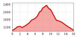
With an ascent of 1411 vertical meters and a descent of 1399 vertical meters over a distance of 16 kilometers, this tour is a real challenge. However, it is not only the altitude difference that makes it demanding, but also the variety of trail conditions. From leisurely forest paths and steep forest trails to rope-secured passages in the rocks, it has it all.
The exertions are rewarded, however, as the breathtaking views accompany you throughout the entire tour. The majestic peaks and expansive valleys will quickly make you forget your efforts.
Be ready for this adventure and experience the beauty of the Tschirgant crossing. But don't forget: safety always comes first! Plan your tour carefully and adapt your pace to the conditions.
information on the current bus times can be found here:
Startseite • Verkehrsverbund Tirol (vvt.at)
Hikers' parking lot in Karrösten


