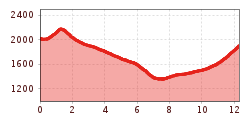
Stage 19 involves plenty of knee-punishing descents, but the wow factor far exceeds the “ow” factor – this walk delivers much reward for the effort. The exposed and rugged trail from Anhalter Hütte to the Steinjöchl ridge is assisted by a fixed anchoring system of cables. From the ridge, it’s a steep descent to the Hahntennjochsattel. Gorgeous scenery awaits eager hikers in the remote Pfafflar Valley, passing picture-postcard villages en route to the Angerletal Valley and to the finishing point of this stage: Hanauer Hütte. Most of the 38 km² Muttekopf nature reserve lies above the treeline, so you'll find yourself in a true alpine environment. Don’t forget to turn your focus from the beautiful scenery to your feet as rare, exotic and endangered alpine wildflowers and plants can be found here.
Medium-difficulty stage on red mountain paths. The steep ascent and descent passages in particular require very good surefootedness and walking technique. Alpine knowledge and climbing experience are required for the rope-secured passage to Steinjöchl. Particular caution is advised in wet conditions. Very good physical condition required.

trail description: Start off at Anhalter Hut, descend a few metres westward and then ascend leisurely up to Steinjöchl Saddle (some cable safeguards) on a singletrack trail. Beyond the dip, the trail descends rather steeply, but soon continues to lead downward more gradually through meadows and dwarf pines. You’ll traverse the slopes in south-western direction and head towards Hahntennjoch Saddle with its rugged, Alpine scenery. At the point where the route leads up to the road, follow the red blazes across Alpine pastures, descending on the right side on a singletrack trail in western direction. A short distance beyond, follow signage to “Hanauer Hütte”. The route runs north of the road along a path and further down gently descending on a dirt road through Alpine pastures, dwarf pines and mixed forest. In this section, you will also walk through a little ravine for a short distance. Where the road bends sharply to the left, the trail winds down on a grass strip north of the road (Trail No. 601 is way-marked on the wall). Soon, you will reach the homes of Pfafflar (here, one could branch off into Fundaistal Valley to Galtseite Col for the alternative access route to Hanauer Hut).
For the original route, however, walk through Pfafflar on the road until a signed (“Nach Boden”) track heads to the left; this is where you will cross the road and the creek. Thereafter, descend on an idyllic singletrack trail along the creek (at the point where a group of homes can be found, one can also branch off to Galtseite Col for the alternative route).The original route descends westward, alternately on a singletrack trail and on a dirt road, down to the hamlet of Boden and to the parking area for Hanauer Hut. Some parts of the descent are rather steep. At the parking area, cross Fundaisbach Creek and follow signage to “Hanauer Hütte”. The route now runs on a well-maintained dirt road and crosses Angerlebach Stream, leading into Angerletal Valley. After the bridge, the route gently ascends again and takes you through groves. Soon, you can catch the first glimpse of Hanauer Hut, which is located on an upland plateau high above the valley. Thereafter, the path descends a few metres before ascending again through Angerletal Valley next to the broad rubble streambed in wide open terrain. At the base of the telpher line, the dirt road turns onto a singletrack trail that steeply zigzags up to the hut (do stay on the summer route). Hanauer Hut is situated at an elevation of 1,922 metres and towered by majestic Kogelseespitze Spire in the backdrop.