Cascading waterfalls, rushing streams, towering seracs and views of glistening glaciers. Welcome to the Eagle Walk in East Tirol! Trailhead of stage 1 is at Prägraten a.G./Ströden, close to the spectacular Umbalfälle waterfalls. Starting under a canopy of ancient larch trees, the trail begins its long and winding way up the mountain. As it breaks out of the woods, keep an eye out for marmots which can often be seen here on a sunny day. Walking past the Göriach Ochsner Hütte, the route continues to the Essener-Rostocker Hütte that provides the perfect rest stop for hikers. Follow the "Schweriner Weg" trail beneath the Kleiner Geiger mountain on your way to the Türml col. Rock cairns as trail markers will show you the way to Johannis Hütte, the oldest mountain refuge in the Eastern Alps. The hut dates back to 1857 and was completely refurbished in 1999. It's a little long and a little challenging getting to the Johannis Hütte, but the scenic rewards are more thn worth it.
Medium-difficult, physically demanding stage on red mountain paths. The route runs along hairpin bends, over scree and snow hollows. Good surefootedness, concentration and alpine knowledge required.

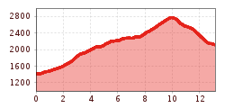
trail description: Trailhead is the car park at Ströden. Having crossed the bridge, the trail begins to work its way up to Stoanalm (elev. 1,450m), running parallel to Maurerbach Creek. A dirt road runs to the base of the telpher line, from where a steep path under a canopy of ancient larch trees begins its long and winding way up the mountain. The 20+ switchbacks up to Göriach Ochsner Hut (elev. 1,948m) entail some 500 metres of climbing. The steep grade lessens and the trail continues, still close to the creek, working its way up to the peaks of Venediger Range, all topped in ice. Cross the bridge of roaring Maurerbach Creek at Upper Ochsner Hut. The mighty creek is the divide between Göriach Alpine Pasture and Maurer Alpine Pasture to the west. Another steep section brings you up to Essener-Rostocker Hut, encircled by the lateral moraines of Simony Glacier that has retreated significantly over the last few years.
Essener-Rostocker Hut provides the perfect rest stop for hikers. From the hut, follow Schwerin Trail and continue up a couple switchbacks for an hour. The trail climbs the boulder-strewn east flank of Kleiner Geiger Mountain on its way towards the red rocks of Türml Peak, passing glacial boulders with striations left over from the last ice age and scree and talus slopes. 2,772-metre Türml Col is situated on foot of Türml Peak. Descend to the east over snowfields and rocks across the east flank of Dorferkamm for about 15 minutes. Then, swing northeast along the crags of Aderkamm and cross a few unbridged creeks. Eventually, cut down below the crags heading south to Dorferbach Creek, where glacial boulders with striations are to be found. Cross the creek by footbridge and wander across meadows, passing a memorial cross and Zettalunitzbach Creek to reach your destination end of this walk, ample Johannis Hut (elev. 2,121m).