Mountain hikes Hike to Kalser Tauernhaus

Kals am Großglockner / Glocknergruppe
Difficulty ratings: medium
Route length: 12.2 km
Duration: 4:00 h

Ideal family excursion destination: The Kalser Tauernhaus in the middle of pine forests and alpine meadows delights with an adventure playground and excellent cuisine. Children, enjoy yourselves!

Tour character

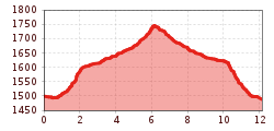
The beautiful, technically easy hike through Dabaklamm and Dorfertal from Gasthof Taurer behind Kals to the Kalser Tauernhaus covers approx. 6 kilometers and takes about 2 hours. Even children will be happy to join you, especially as there is an adventure playground and a cozy inn with first-class food waiting at the end. Not far from the Kalser Tauernhaus is the famous landslide natural jewel Dorfer See.

Tour information

  • Requirement: medium
  • Length: 12.2 km
  • Duration: 4:00 h
  • Elevation uphill:244 hm
  • Elevation downhill:264 hm
Highest point1,755 m

Starting point

Parkplatz Dorfertal

Finishing point

Parkplatz Dorfertal
Source: Nationalparkregion Hohe Tauern Osttirol

Description

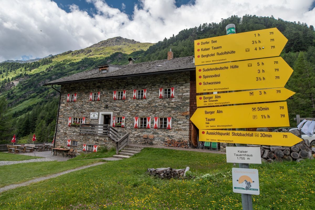
Via the Bergeralm snack station (children's playground), you continue on an easily accessible hiking trail to the Kalser Tauernhaus at 1,755 metres. In another 20 min. and after an ascent you reach another viewing pulpit at the Stotzbachfall (offers beautiful photo motifs of the break-offs of Laperwitz- and Fruschnitzkees)

Along the way, the national park administration has set up an educational trail, the Dorfertal Geschichte(n)weg (story trail)), a kind of "audio trail". In so-called “audio trees", voices from mountain farmers, dairymaids, mountain guides, hut owners and other well-informed citizens of Kals tell about life in the alpine valley. Stories taken from life, funny, moving, but also shocking events from many decades. There are also information boards on the nature and culture of Dorfertal. A solid viewing pulpit entices bold views into the roaring depths of the Dabaklamm Gorge — a spectacular highlight especially for children! The path to the Tauernhaus can also be mastered with a robust buggy.

Nearby huts and mountain restaurants

More tours in the surrounding area

  • Hiking tour to Lasörlinghütte 2.350m

    Difficulty: medium
    Length: 14.6 km Duration: 7:10 h Elevation uphill: 1,080 m
  • Badener Hütte

    Difficulty: difficult
    Length: 23.2 km Duration: 11:30 h Elevation uphill: 1,750 m
  • Lasörling altitude trail

    Difficulty: medium
    Length: 57.0 km Duration: 25:00 h Elevation uphill: 3,740 m
  • Figerhorn

    Difficulty: difficult
    Length: 6.5 km Duration: 6:00 h Elevation uphill: 807 m
  • Rotenkogel

    Difficulty: difficult
    Length: 3.9 km Duration: 3:00 h Elevation uphill: 383 m
  • Umbal waterfalls nature force trail

    Difficulty: easy
    Length: 5.8 km Duration: 2:30 h Elevation uphill: 250 m
  • Lasörling 3.098m

    Difficulty: difficult
    Length: 21.9 km Duration: 12:00 h Elevation uphill: 1,940 m
  • Hike to Neuen Reichenberger Hütte

    Difficulty: medium
    Length: 9.1 km Duration: 9:00 h Elevation uphill: 1,210 m
  • Hiking tour to Neue Sajathütte 2.600m

    Difficulty: medium
    Length: 10.3 km Duration: 6:50 h Elevation uphill: 1,080 m
  • Lucknerhaus - Stüdlhütte

    Difficulty: medium
    Length: 9.3 km Duration: 5:30 h Elevation uphill: 862 m
  • Böses Weibl

    Difficulty: difficult
    Length: 14.1 km Duration: 8:00 h Elevation uphill: 1,193 m
  • Muhs panorama trail

    Difficulty: medium
    Length: 15.2 km Duration: 6:00 h Elevation uphill: 1,090 m
  • Venediger altitude trail

    Difficulty: difficult
    Length: 55.5 km Duration: 27:00 h Elevation uphill: 3,915 m
  • Hike to the Venedigerhaus Innergschlöß

    Difficulty: easy
    Length: 8.5 km Duration: 2:30 h Elevation uphill: 180 m
Newsletter

The mountain is calling? So does our newsletter!

In our monthly newsletter we reveal the best holiday tips for Tyrol.