Mountain hikes Siegerlandhütte - Sölden

Sölden / Stubaier Alpen
Difficulty ratings: medium
Route length: 8.0 km
Duration: 3:30 h

Coincidence or destiny? The members of the DAV Siegerland section certainly felt like winners when they were assigned the upper Windachtal valley as their working area in the 1920s: An untouched corner in the Stubai Alps, surrounded by the proud summits of several three-thousand-metre peaks.

Tour character

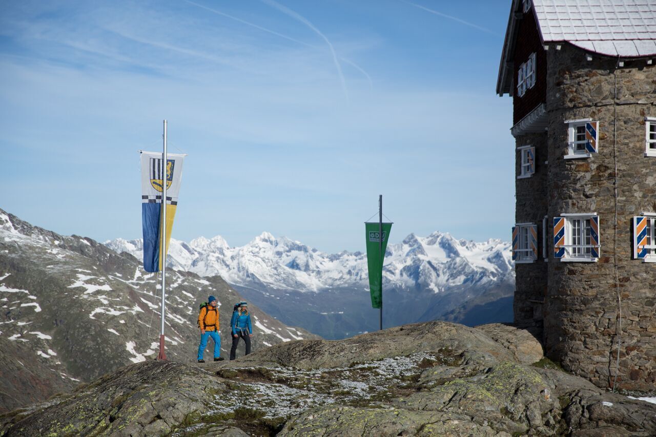
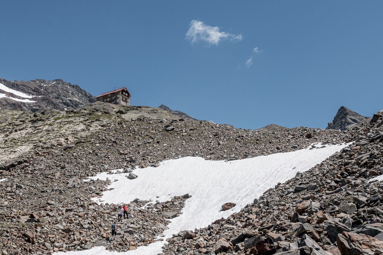
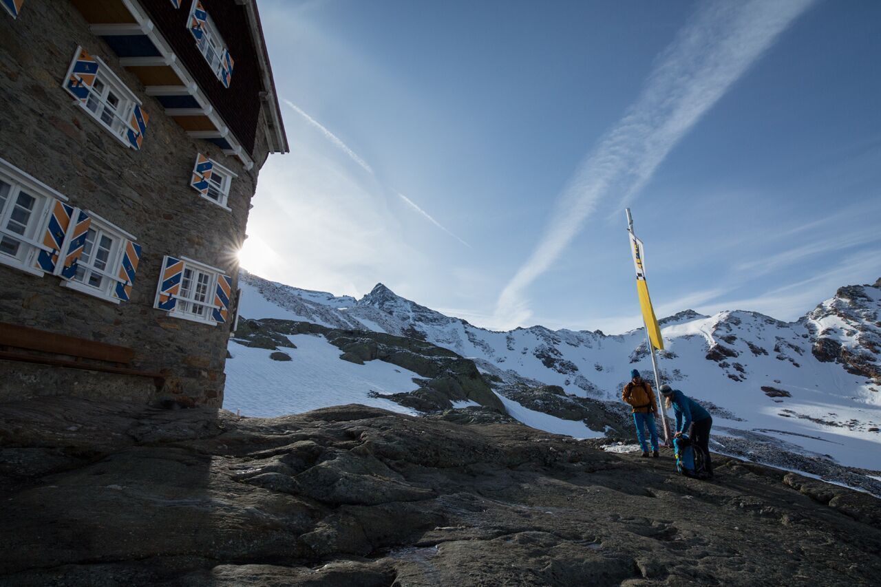
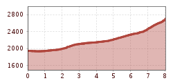
The hike to the Siegerlandhütte offers a varied mix of quiet valley sections, alpine ascents and vast high mountain landscapes. The trail leads through the idyllic Windachtal valley before turning into steeper, more challenging sections. In the final section, the route winds its way through a wide cirque up to the hut at 2,710 m above sea level.

Tour information

  • Requirement: medium
  • Length: 8.0 km
  • Duration: 3:30 h
  • Elevation uphill:780 hm
  • Elevation downhill:11 hm
Highest point2,710 m

Starting point

Windachalm/ Fiegl's guesthouse - Sölden

Finishing point

Siegerland Hut
  • Fitness level 4 / 6

Best time of year

  • January
  • February
  • March
  • April
  • May
  • June
  • July
  • August
  • September
  • October
  • November
  • December

Equipment

Red mountain trails are moderately difficult: some narrow and steep but secured walking and climbing passages await hikers. The corresponding signs are in a yellow base color and feature a red circle as the difficulty level indicator.

Moderately difficult mountain path; suitable for sure-footed and experienced mountain hikers; good physical condition, mountain experience and mountain equipment (see under equipment) are necessary.

Please check the current weather report at: https://www.oetztal.com/de/sommer.html

Appropriate equipment such as breathable and weather-appropriate outdoor clothing, ankle-high hiking boots, wind, rain and sun protection, a hat and possibly gloves are recommended! It is also important to bring sufficient provisions as well as a first aid kit, a mobile phone and possibly a hiking map.

Source: Ötztal

Description

The Siegerland hut stands on a height of 2,710m - directly at the foot of the highest mountains in the Stubai Alps.

The hike starts at Windachalm/ Fiegl's hut and continues through the wide Windach valley to the Siegerland hut.

Enjoy the view of the gentle pasture areas, deep gorges, a waterfall and glacial polish.


Nearby huts and mountain restaurants

Getting here

  • Arrival by public transport

    Travel comfortably and safely by train to the Ötztal train station. The final stop or exit point is ÖTZTAL station. Afterwards you can conveniently and quickly travel through the entire valley to your desired destination with public transportation or local taxi companies.

    The current bus schedule is available at: http://fahrplan.vvt.at

  • Parking

    The following parking options are available in Sölden:

    • Postplatz parking lot
    • Giggijochbahn + underground car park
    • Gaislachkoglbahn + underground car park

    The parking lots in Sölden are subject to a fee.

    For parking over several days (e.g. hut route):

    • Gaislachkoglbahn parking garage - parking ticket either online or directly at the Gaislachkoglbahn ticket office

More tours in the surrounding area

  • Ötztal Trek Stage 3

    Difficulty: difficult
    Length: 10.4 km Duration: 4:00 h Elevation uphill: 842 m
  • Ötztal Trek Stage 10

    Difficulty: difficult
    Length: 11.1 km Duration: 4:30 h Elevation uphill: 1,476 m
  • Ötztal Trek Stage 1

    Difficulty: medium
    Length: 18.6 km Duration: 6:30 h Elevation uphill: 1,561 m
  • Ötztal Trek Stage 14

    Difficulty: difficult
    Length: 6.3 km Duration: 3:00 h Elevation uphill: 1,004 m
  • Ötztal Trek Stage 11

    Difficulty: difficult
    Length: 12.0 km Duration: 5:00 h Elevation uphill: 705 m
  • Winter hiking trail Rotes Wandl - No. 431

    Opening hours: closed
    Difficulty: easy
    Length: 1.5 km Duration: 0:45 h Elevation uphill: 52 m
  • Ötztal Trek Stage 21

    Difficulty: difficult
    Length: 9.4 km Duration: 4:30 h Elevation uphill: 1,270 m
  • Ötztal Trek Stage 6

    Difficulty: difficult
    Length: 7.6 km Duration: 3:30 h Elevation uphill: 640 m
  • Ötztal Trek Stage 17

    Difficulty: difficult
    Length: 16.4 km Duration: 6:00 h Elevation uphill: 1,080 m
  • Mountain peak Rosskopf

    Difficulty: medium
    Length: 2.0 km Duration: 2:00 h Elevation uphill: 379 m
  • Mutsbühl

    Difficulty: medium
    Length: 4.5 km Duration: 1:30 h Elevation uphill: 470 m
  • Fundusfeiler - Umhausen

    Difficulty: difficult
    Length: 4.5 km Duration: 3:00 h Elevation uphill: 1,109 m
  • Wilder Mann

    Difficulty: medium
    Length: 2.4 km Duration: 2:30 h Elevation uphill: 665 m
  • Loop trail Stuibenfall Umhausen

    Opening hours: open
    Difficulty: easy
    Length: 9.2 km Duration: 4:00 h Elevation uphill: 608 m
  • Gampe Thaya

    Difficulty: medium
    Length: 2.6 km Duration: 1:45 h Elevation uphill: 623 m
  • Ramolhaus - Obergurgl

    Difficulty: difficult
    Length: 7.8 km Duration: 4:00 h Elevation uphill: 1,095 m
Newsletter

The mountain is calling? So does our newsletter!

In our monthly newsletter we reveal the best holiday tips for Tyrol.