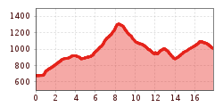
After a good night’s sleep in Pinegg, take a walk from the Gasthof Gwercherwirt Inn over the bridge across the Brandenberger Ache river and follow the Jägersteig path all the way to Aschau, a hamlet of Brandenberg. Take the paved road to get to Burgstallgraben, from where the path winds up to Wimm, Wimmerjoch peak and the old Lahnalm hut. From there, walk across Weißenbachgraben gorge to reach the “most beautiful end of the world”: Steinberg am Rofan. The surroundings are so beautiful that it is tempting to stay for a while, but use your new-found energy and continue on the Eagle Walk a little further. Cross the Steinberger Ache river to get to Vordersteinberg, then take the Bärenwald path through the forest to the cosy Waldhäusl guesthouse, where it is possible to stay overnight.
Medium-difficulty stage on red mountain paths. Sure-footedness and good walking technique are absolutely essential, as is a good level of fitness – the walking time of around 7 hours is quite demanding.

Starting point: Gasthof Gwercherwirt (Pinegg)
Start out in Pinegg and cross the Brandenberger Ache and Steinberger Ache rivers via two beautiful bridges. Once across the rivers, continue up through magnificent old-growth forest on a hiking trail that eventually merges onto a forest road and rejoins Jägersteig path later, taking you to Aschau, which is a tiny settlement of Brandenberg.
Food & drink: Jodlerwirt, Haaser
Climbing steeply, the trail works its way up to the last farm named "Wimm". After the cattle grid, turn right and continue to follow the signs as far as the Wimmerjoch ridge. Here, at the highest point on today's stage, it is worth taking a break in the lush green meadows. Then stay left and head down towards the Lahnalm hut. Shortly before reaching the hut, follow the path to "Weißenbachgraben". As soon as you have crossed the Weißenbach, marking the border between Brandenberg and Steinberg, it is just a short stretch to the impressive Enterhof farmstead, where it is possible to stay the night. Continue past the farmstead and down to Steinberger Loch, crossing the Steinberger Ache river for the second time. Then take the first turning right onto the "Hinterbergweg" path. Follow it north as far as Vordersteinberg, cross the road and continue to the "Bärenwaldweg" path. All that remains is to follow this trail to the idyllic Gasthof Waldhäusl on the western edge of Steinberg. Hikers can stay the night here.
Finishing point: Gasthof Waldhäusl (Steinberg)