Mountain hikes Day 2: 4 days - 4 summits tour

Brandenberg / Brandenberg Alps (Rofan)
Difficulty ratings: medium
Route length: 20.3 km
Duration: 7:00 h

The mountain pine-covered Kienberg is the highest viewing point on the second stage. The descent takes you back towards Brandenberg, to the pretty district of Pinegg.

Tour character

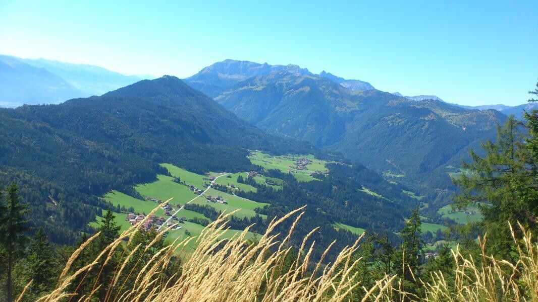
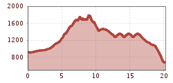
The second day leads from Brandenberg via the idyllic but unmanaged Jocheralm to the imposing Kienberg at 1,786 meters. Good paths and tracks then lead down to the Brandenberg district of Pinegg. The six- to seven-hour hike of moderate difficulty offers wonderful views of the Rofan and Karwendel mountains, the Guffert and the Kitzbühel and Zillertal Alps.

Tour information

  • Requirement: medium
  • Length: 20.3 km
  • Duration: 7:00 h
  • Elevation uphill:1,198 hm
  • Elevation downhill:1,451 hm
Highest point1,786 m

Starting point

Brandenberg

Finishing point

Brandenberg/Pinegg
  • Fitness level 4 / 6

Best time of year

  • January
  • February
  • March
  • April
  • May
  • June
  • July
  • August
  • September
  • October
  • November
  • December

Equipment

Sure-footedness is required when descending from Heuberg!

Sturdy shoes, weatherproof clothing

Source: Alpbachtal Tourismus

Description

Day 2: From Brandenberg via Jocheralm to Kienberg and descent to Pinegg --> 6 - 7 h

Your day starts in the picturesque Brandenberg, where you set off towards the district "Winkel." Along the sidewalk, you hike about 3 kilometers until you reach the intersection "Kink/Pumphaus." Here you follow the signs towards Jocheralm/Kienberg/Plessenberg and take the steep asphalt road upwards.

After passing the cattle grid, turn left for about 300 meters on the forest road to the sign "Alter Steig." Here you can choose: you can either hike to Jocheralm on the forest road or take the old path. For a varied experience, we recommend the path, which offers you a new perspective on the surroundings.

From Jocheralm, follow the signs towards "Kienberg/Plessenberg." The brave summit climbers among you take the route over the Heuberg, Heubergsattel and finally to the majestic Plessenberg at 1,743 meters elevation. From here, enjoy a breathtaking view into the Inn Valley, which more than justifies the additional time of about 1 hour and 30 minutes.

For an easier variant, the path leads directly from Jocheralm to Kienberg. This route takes about 3 hours and 30 minutes and still offers spectacular views and unforgettable experiences.

From the summit cross of Kienberg, it is then only downhill. Over the inns and Heubrandalm, you hike to "Prama" and from there descend on a steep path to Pinegg.

With many new impressions and memories in your backpack, you complete the second day of your hike and look forward to the adventures the following day will bring.

Overnight stay:

Gasthof Gwercherwirt


Nearby huts and mountain restaurants

Getting here

  • Parking

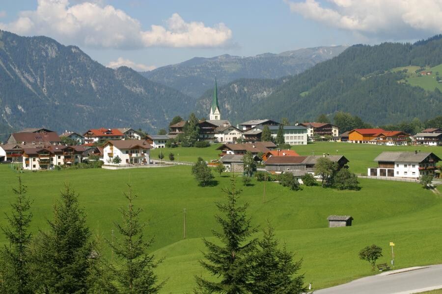
    Brandenberg village center

Weather

Today

cloudy
17°C/6°C
20%1.2l10 km/h

Wed

mainly clear
14°C/3°C
15%0.7l10 km/h

Thu

clear sky
15°C/1°C
0%0l10 km/h
Go to weather forecast

More tours in the surrounding area

  • Voldöpper Spitze Loop Hike

    Difficulty:medium
    Length:12.9 kmDuration:5:00 hElevation uphill:988 m
  • Day 1: 4 days - 4 summits tour

    Difficulty:medium
    Length:9.8 kmDuration:5:00 hElevation uphill:984 m
  • 3-peak-tour Kienberg-Plessenberg-Heuberg

    Difficulty:medium
    Length:8.6 kmDuration:4:30 hElevation uphill:779 m
  • Day 3: 4 days - 4 summits tour

    Difficulty:medium
    Length:19.3 kmDuration:8:00 hElevation uphill:1,371 m
  • 4 days - 4 summits tour

    Difficulty:medium
    Length:54.4 kmDuration:23:00 hElevation uphill:3,408 m
  • 3-day Family Tour Alpbachtal

    Difficulty:easy
    Length:18.3 kmDuration:7:00 hElevation uphill:998 m
  • Loop tour Juppi Zauberwald

    Difficulty:easy
    Length:2.5 kmDuration:1:00 hElevation uphill:93 m
  • Kundler Klamm

    Difficulty:easy
    Length:6.4 kmDuration:2:00 hElevation uphill:116 m
  • Farmkehralm 1.521 m

    Difficulty:medium
    Length:9.3 kmDuration:3:30 hElevation uphill:506 m
  • Barrier-free path Lake Reintal

    Difficulty:easy
    Length:6.5 kmDuration:1:45 hElevation uphill:15 m
  • Discovering the Tiefenbach Gorge Hike

    Opening hours:closed
    Difficulty:medium
    Length:5.7 kmDuration:3:30 hElevation uphill:669 m
  • Kaiser Gorge - loop trail

    Difficulty:easy
    Length:4.2 kmDuration:1:00 hElevation uphill:198 m
Newsletter

The mountain is calling? So does our newsletter!

In our monthly newsletter we reveal the best holiday tips for Tyrol.