Mountain hikes Large Schafkopf, 3.000 m
Nauders /
Difficulty ratings: medium
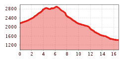
Route length: 16.8 km
Duration: 8:00 h

Large Schafkopf, 3.000 m

Tour information

  • Requirement: medium
  • Length: 16.8 km
  • Duration: 8:00 h
  • Elevation uphill:917 hm
  • Elevation downhill:1,655 hm
Highest point3,000 m

Starting point

Bergkastel Bergstation

Finishing point

Nauders

Equipment

- feste Trekking- oder Bergschuhe mit Gummiprofilsohle - Kleidung angepasst an Temperatur: kurze Hose, Funktionsshirt und Kopfbedenkung bei Sonnenschein, Anorak mit Kapuze, Überhose oder lange Hose, Regenschutz, Mütze & Handschuhe, - Teleskopstöcke - Tagesrucksack mit Trinkflasche, Proviant und Sonnenschutz - Kamera, Fernglas, Handy, Erste Hilfe
Source: Nauders - Tiroler Oberland - Kaunertal

Description

The summit tour is one of the highlights of the mountain tours in Nauders. After the Bergkastel cable car ascent, follow the signposted paths up to the Goldsee lakes. From there continue to Perdossscharte. To the east, a ridge first leads to the summit of the Mataunkopf (2,865 m). The route continues directly along the border between Italy and Austria (No. 45), with a deep view of Langtauferertal, to the large Schafkopf (3,000 m). To get back, either descend via Trail No. 21 or via the somewhat more difficult Trail No. 31 to the upper Mataun pastures. The route continues through Saletztal and over mountain meadows (No. 23) to Piengalm. Trail no. 19a leads back to the Bergkastel mountain station. A longer descent variant leads from Piengalm on Trail no. 19a to the mountain resort of Jochelius. From there the route goes over the Holy Tree pastures on foot into the valley.
 

More tours in the surrounding area

Newsletter

The mountain is calling? So does our newsletter!

In our monthly newsletter we reveal the best holiday tips for Tyrol.