
Mountain hikes Laudeck Sauerbrunn Rundsteig

open
Ladis / Samnaun Group
Difficulty ratings: medium
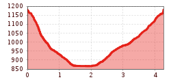
Route length: 4.3 km
Duration: 2:30 h

A varied circular trail around Ladis, with Laudeck Castle and the Sauerbrunn spring as highlights along the route. The trail combines historic sights with peaceful forest and meadow paths.
Tour information

  • Requirement: medium
  • Length: 4.3 km
  • Duration: 2:30 h
  • Elevation uphill:322 hm
  • Elevation downhill:316 hm
Highest point1,180 m

Starting point

Castle pond in Ladis

Finishing point

Castle pond in Ladis
  • Fitness level 2 / 6

Features

  • Circular route

Best time of year

  • January
  • February
  • March
  • April
  • May
  • June
  • July
  • August
  • September
  • October
  • November
  • December
Source: Serfaus-Fiss-Ladis

Description

From the Castle Path towards Laudeck Castle and then continuing to the right at the end of the Castle Pond. The descending “Muggalsteig” trail features a unique view of Laudeck Castle towards Prutz. The Sauerbrunn Spring is located left towards the campsite. (One of the most famous and oldest Tyrolean mineral springs. Water from Obladis was already delivered to the court at Innsbruck as far back as the 16th century. Nobles from Switzerland as well as from the surrounding area of Bavaria visited Obladis to regain their health through the water). Past the campsite, take the first turnoff left towards the Asterhof mountains. Take a left on the dirt track just before the last house “Waldheim” and follow the “Panzerweg” trail back to the starting point:
the castle pond in Ladis.

Getting here

  • Arrival by public transport

    Take the bus to Ladis village. From there, walk to Lader Schlossweiher, the starting point of the tour.

  • Parking

    Parking is available in Ladis. Depending on the starting point of the tour, different car parks are available. The car parks are subject to a fee.

Weather

Today

light rain showers
20°C/11°C
85%20.1l5 km/h

Thu

cloudy
17°C/9°C
50%0.2l5 km/h

Fri

light rain
16°C/9°C
70%5.7l5 km/h
Go to weather forecast

More tours in the surrounding area

  • Marmot Trail

    Opening hours:open
    Difficulty:easy
    Length:573 mDuration:0:20 hElevation uphill:12 m
  • Wild Animals Trail

    Opening hours:open
    Difficulty:easy
    Length:1.5 kmDuration:0:31 hElevation uphill:1 m
  • Panorama - Genussweg

    Opening hours:open
    Difficulty:easy
    Length:1.1 kmDuration:1:15 hElevation uphill:282 m
  • Oberer Spinnsee

    Opening hours:open
    Difficulty:medium
    Length:11.2 kmDuration:5:00 hElevation uphill:427 m
  • Fiss to the Oberen Sattelkopf

    Opening hours:open
    Difficulty:medium
    Length:5.6 kmDuration:3:00 hElevation uphill:1,057 m
  • Forscherpfad

    Opening hours:open
    Difficulty:easy
    Length:3.4 kmDuration:1:30 hElevation uphill:219 m
  • Six Senses trail

    Opening hours:open
    Difficulty:easy
    Length:6.5 kmDuration:4:00 hElevation uphill:99 m
  • Murmeltiersteig (Marmot alpine trail)

    Opening hours:open
    Difficulty:medium
    Length:6.9 kmDuration:3:00 hElevation uphill:302 m
Newsletter

The mountain is calling? So does our newsletter!

In our monthly newsletter we reveal the best holiday tips for Tyrol.
