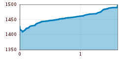
DescriptionFrom Serfaus over the Zeno Brücke bridge (S088) followedby a short, steep ascent to Apart Pamela (S091). Hike on the asphalted road, ascent only minimal to Madatschen (hamlet of Serfaus).
neuer-wanderweg-im-stilluptal-foto-stefan-absenger © Archiv TVB Mayrhofen Themed hike: Stilluptal "Wasserfallweg"Difficulty:easyLength:15.3 kmDuration:5:00 hElevation uphill:325 mSee trailSee trail: Themed hike: Stilluptal "Wasserfallweg"
Hoch oben an der Rastkogelhütte © Archiv TVB Mayrhofen Circuit & summit hike: Schwendberg (Jausenstation Melchboden) Arbiskopf, Rauhenkopf and KreuzjochDifficulty:mediumLength:8.6 kmDuration:3:30 hElevation uphill:450 mSee trailSee trail: Circuit & summit hike: Schwendberg (Jausenstation Melchboden) Arbiskopf, Rauhenkopf and Kreuzjoch
Blick nach Vorderhornbach © Lechtal Tourismus Stanzach - Baichlstein - high trail to VorderhornbachDifficulty:mediumLength:10.0 kmDuration:3:10 hElevation uphill:271 mSee trailSee trail: Stanzach - Baichlstein - high trail to Vorderhornbach
©-TVB-Tiroler-Oberland-Daniel-Zangerl-Winterwandern-Pfundser-Tschey-2019 (23).jpg © danielzangerl Pfundser Tschey winter hiking trailOpening hours:closedDifficulty:easyLength:5.1 kmDuration:1:39 hElevation uphill:120 mGo to winter hikeGo to winter hike: Pfundser Tschey winter hiking trail
Tschirgant Karr+Âster Kreuz_IMG_8349.jpg © @imst-tourismus Auf den Tschirgant über die BergwachthütteDifficulty:mediumLength:14.0 kmDuration:6:30 hElevation uphill:1,300 mSee trailSee trail: Auf den Tschirgant über die Bergwachthütte
Muttekopf (No. 621)Difficulty:mediumLength:9.2 kmDuration:6:00 hElevation uphill:966 mSee trailSee trail: Muttekopf (No. 621)
Lech bei Forchach. © Lechtal Tourismus Stanzach - Over the suspension bridgeDifficulty:easyLength:12.8 kmDuration:3:15 hElevation uphill:42 mSee trailSee trail: Stanzach - Over the suspension bridge
Kundl GorgeDifficulty:easyLength:6.5 kmDuration:3:00 hElevation uphill:10 mSee trailSee trail: Kundl Gorge
Blick vom Juifen ins Karwendel © Achensee Tourismus Achenkirch - Falkenmoosalm - Großzemmalm - Juifen - AchenkirchDifficulty:mediumLength:20.5 kmDuration:7:30 hElevation uphill:1,120 mSee trailSee trail: Achenkirch - Falkenmoosalm - Großzemmalm - Juifen - Achenkirch
Hängebrücke Namlos © Außerhofer Hanspeter Namlos - FallerscheinDifficulty:easyLength:3.8 kmElevation uphill:119 mSee trailSee trail: Namlos - Fallerschein
Kaiserjochhaus © Lechtal Tourismus Lechtaler Höhenweg: 3. Etappe Kasierjochhaus-Ansbacher HütteDifficulty:difficultLength:7.8 kmDuration:4:45 hElevation uphill:844 mSee trailSee trail: Lechtaler Höhenweg: 3. Etappe Kasierjochhaus-Ansbacher Hütte
die Gufferthütte - sie gehört der Deutschen Alpenvereinssektion Mühldorf a. Inn © Achensee Tourismus Achenkirch - Geopfad Obere Ampelsbach- und Filzmoosbach Schlucht - Gufferthütte - AchenkirchDifficulty:mediumLength:15.2 kmDuration:4:30 hElevation uphill:490 mSee trailSee trail: Achenkirch - Geopfad Obere Ampelsbach- und Filzmoosbach Schlucht - Gufferthütte - Achenkirch
Klang des Holzes © © Serfaus-Fiss-Ladis Marketing GmbH Six Senses trailOpening hours:openDifficulty:easyLength:6.5 kmDuration:4:00 hElevation uphill:99 mSee trailSee trail: Six Senses trail
swiss-track02-c-npht-martin-kurzthaler.jpeg © Nationalpark Hohe Tauern / Martin Kurzthaler Rollitour with Swiss TracDifficulty:easyLength:3.2 kmDuration:1:30 hElevation uphill:135 mSee trailSee trail: Rollitour with Swiss Trac
Stage 7: Bremer Hut - Innsbrucker HutDifficulty:difficultLength:9.5 kmDuration:7:00 hElevation uphill:839 mSee trailSee trail: Stage 7: Bremer Hut - Innsbrucker Hut
Stage 4: Dresdner Hut - Sulzenau HutDifficulty:difficultLength:5.0 kmDuration:3:00 hElevation uphill:419 mSee trailSee trail: Stage 4: Dresdner Hut - Sulzenau Hut
Ascent to the Starkenburger HutDifficulty:mediumLength:3.9 kmDuration:1:30 hElevation uphill:324 mSee trailSee trail: Ascent to the Starkenburger Hut
Blaue Lacke und SulzenaufernerDifficulty:mediumLength:2.5 kmDuration:1:15 hElevation uphill:481 mSee trailSee trail: Blaue Lacke und Sulzenauferner
andreschoenherrPANO0009-6-Pano.jpg © TVB Stubai Winter walk to the Gleinserhöfe, Stubai ValleyDifficulty:mediumLength:5.6 kmDuration:1:30 hElevation uphill:83 mGo to winter hikeGo to winter hike: Winter walk to the Gleinserhöfe, Stubai Valley
imagemeta.apiv2.1593523029518 © TVB Stubai Sulzenau Hütte - Blaue Lacke und GrünauseeDifficulty:mediumLength:3.2 kmDuration:1:07 hElevation uphill:117 mSee trailSee trail: Sulzenau Hütte - Blaue Lacke und Grünausee
andreschoenherr_DSC1420.jpg © TVB Stubai Descent from the Innsbrucker HutDifficulty:mediumLength:12.6 kmElevation uphill:25 mSee trailSee trail: Descent from the Innsbrucker Hut
Sulzautal.jpg © TVB Stubai WildeWasserWeg: (Stage 2) Grawa Wasserfall - Sulzenau Alm - SulzenauhütteDifficulty:mediumLength:4.3 kmDuration:2:30 hElevation uphill:676 mSee trailSee trail: WildeWasserWeg: (Stage 2) Grawa Wasserfall - Sulzenau Alm - Sulzenauhütte
Sulzenauer Becken2.JPG © TVB Stubai WildeWasserWeg: all stagesDifficulty:mediumLength:9.6 kmDuration:5:10 hElevation uphill:1,165 mSee trailSee trail: WildeWasserWeg: all stages
Stage 3: Neue Regensburger Hut - Dresdner HutDifficulty:difficultLength:13.0 kmDuration:7:00 hElevation uphill:1,033 mSee trailSee trail: Stage 3: Neue Regensburger Hut - Dresdner Hut
Stage 5: Sulzenau Hut - Nürnberger HutDifficulty:difficultLength:4.4 kmDuration:4:00 hElevation uphill:461 mSee trailSee trail: Stage 5: Sulzenau Hut - Nürnberger Hut
Give feedback for a chance to win a special holiday experience!Click here for the surveyClick here for the survey